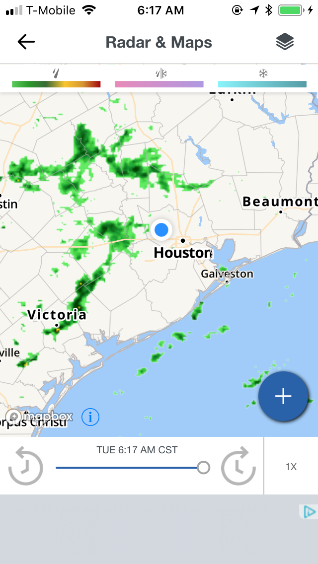
Houston, TX radar, during the early morning.

Northwest Houston, TX, during the early morning.


Houston, TX radar, during the late morning.

Houston, TX radar, during the early afternoon.

Houston, TX radar, during the early evening.

Northwest Houston, TX, during the early evening.
Locations: Northwest Houston, TX
Thoughts: The day was cool, wet, and cloudy. Scattered moderate to moderately heavy and heavy thunderstorms passed through the Houston, TX area, during the morning and part of the early afternoon. I think there was some isolated light to moderate showers and drizzle, during the rest of the afternoon, evening, and night.
Area Forecast Discussion
Issued by NWS Houston/Galveston, TX
Issued by NWS Houston/Galveston, TX
Versions: 1 2 3 4 5 6 7 8 9 10 11 12 13 14 15 16 17 18 19 20 21 22 23 24 25 26 27 28 29 30 31 32 33 34 35 36 37 38 3940 41 42 43 44 45 46 47 48 49 50
000
FXUS64 KHGX 140001
AFDHGX

Area Forecast Discussion
National Weather Service Houston/Galveston TX
601 PM CST Tue Feb 13 2018

.UPDATE...
Area observations have shown visibilities fluctuating in the 1-3
mile range with high resolution guidance showing areas of dense
fog developing overnight as additional low level saturation
occurs. A Dense Fog Advisory has been issued for all of Southeast
Texas and the adjacent coastal waters through mid-morning
Wednesday.

The 00Z Aviation Discussion is also included below.

45

&&

.AVIATION...
Poor flight conditions will persist as IFR/LIFR conditions now
either remain steady or further deteriorate to VLIFR as a warm
front 80 miles south of the upper Texas coast lifts inland by
Wednesday morning. Periods of light drizzle or rain are expected
overnight with little to no improvement until late morning or
early afternoon depending on how much insolation is able to
penetrate a stubborn stratus deck and how quickly the warm front
lifts north. Light and easterly winds will gradually become light
and variable or light and southerly as the warm front lifts
inland. Concerned that MOS guidance is too aggressive with
increasing southerly winds by late morning behind the front as the
surface pressure gradient remains rather weak. This would allow
IFR/LIFR conditions to persist through the afternoon hours.

Huffman

&&

.PREV DISCUSSION... /ISSUED 347 PM CST Tue Feb 13 2018/

DISCUSSION...
The bulk of today`s rain is moving across and out of the
northeastern forecast area late this afternoon. As was the case
yesterday...many communities have struggled to warm more than a
few degrees (5 to 8 degrees) from morning minimum temperatures.
Thus...under overcast and scattered precipitation...the majority
of southeastern Texas will peak out in the middle 40s (north) to
lower 50s (south) or about 15 to 20 degrees below typical Fat
Tuesday standards. A period of quiet weather precipitation-wise
through the evening but...with winds veering back onshore within
the next 12 hours...the inland movement of a near-coastal warm
front on Wednesday will keep at least low end/low QPF precipitation
chances in play over the next 24 hours. Any returning precipitation
will be light and primarily in the form of light mist...rain...or
drizzle. With no discernible shortwave disturbance coming up the
pike and central Gulf-based upper ridging expanding westward onto
the upper Texas coastline...any short term precipitation will be
of this very weak/low accumulation nature.

The two main stories through the remainder of the week will be
the return of maritime dense sea fog and subsequent daily warming
back up to above normal by as early as tomorrow. Dense sea fog
will advect inland and cause significant travel and commence
issues on our local road and waterways. As today`s northeasterly
winds veer more easterly through tonight and stick east-southeast
ahead of the next frontal passage on Friday...lower 60 F dew point
air will travel across low to mid 50 degree bay/shelf waters and
produce the soup. Despite the continued overcast skies...strong
warm air advection will push this trend for near to above normal
temperatures from tomorrow through Friday. A relatively warm start
in the upper 40s to lower 50s per overnight cloud cover/insulation
and southwest flow pushing 85H temperatures into the mid teens
"should" aid in allowing the day to warm into `at least` the
lower 60s by mid-day. With this being said...the current synoptic
set-up has honestly offered some skepticism to such a warm up.
The ARW core of the WRF advertises near 70 F 2m temps while the
NMM core is about 10 degrees cooler. Little to no deviance within
the GEFS/Euro members on pushing at least lower 70s tomorrow. Not
totally biting on either side but have had to throw the dice on a
blend of multiple solutions that still come up with a very warm
next couple of days in the 60s and 70s.

The next cold front is timed to reach the area Friday afternoon
and slowly sag to the coast through the evening hours. Eastern
ridging may slow its southern progress and the forecast does
display this slow trend in lowering post-frontal temperatures and
dew points. Medium range progs keep rain chances ongoing into
Saturday as mid-level focus along the 85H front (maybe exiting
RRQ of southern jet branch?) seems to generate continued QPF
through at least early Sunday. The backing air mass will not have
much of a punch with the coldest and driest air remaining well off
across the Great Lakes region. Warm air advection commences by
early next work week so...after a relatively cooler Saturday in
the average middle to upper 50s...warming back into the 60s/70s
and sea fog will once again be in fashion by this time next week.
31

MARINE...
Winds will gradually veer to the southeast overnight as a warm front
approaches the coast and moves inland. A Warmer airmass moving over
THE cooler shelf waters will lead to periods of dense sea
fog developing. This looks like it could end up being a prolonged
fog event considering the next front isn`t forecast to move off the
coast until Friday night at the earliest...and quite possibly later
than that (model guidance isn`t in the best agreement with the timing
yet). Until then look for moderate to light onshore winds, 2-5 ft
seas and periods of fog & drizzle. 47

&&

.PRELIMINARY POINT TEMPS/POPS...
College Station (CLL)      47  70  62  77  61 /  40  30  20  30  20
Houston (IAH)              50  73  63  78  63 /  40  30  20  30  20
Galveston (GLS)            53  68  63  72  63 /  30  20  20  20  20

&&

.HGX WATCHES/WARNINGS/ADVISORIES...
TX...Dense Fog Advisory until 10 AM CST Wednesday for the following
     zones: Austin...Brazoria...Brazos...Burleson...Chambers...
     Colorado...Fort Bend...Galveston...Grimes...Harris...
     Houston...Jackson...Liberty...Madison...Matagorda...
     Montgomery...Polk...San Jacinto...Trinity...Walker...
     Waller...Washington...Wharton.

GM...Dense Fog Advisory until 10 AM CST Wednesday for the following
     zones: Coastal waters from Freeport to the Matagorda Ship
     Channel out 20 NM...Coastal waters from High Island to
     Freeport out 20 NM...Galveston Bay...Matagorda Bay...Waters
     from Freeport to the Matagorda Ship Channel from 20 to 60
     NM...Waters from High Island to Freeport from 20 to 60 NM.

&&

$$

Discussion...45
Aviation/Marine...14
Dense Fog Advisory
URGENT - WEATHER MESSAGE
National Weather Service Houston/Galveston TX
552 PM CST Tue Feb 13 2018

...Dense fog developing this evening...

.Areas of dense fog are expected to develop across the region with
visibility reduced to 1/4 mile or less. The fog should begin
dissipate around 10 am as warmer southerly winds mix down across
the region.

TXZ163-164-176>179-195>200-210>214-226-227-235>238-141600-
/O.NEW.KHGX.FG.Y.0010.180214T0000Z-180214T1600Z/
Austin-Brazoria-Brazos-Burleson-Chambers-Colorado-Fort Bend-
Galveston-Grimes-Harris-Houston-Jackson-Liberty-Madison-Matagorda-
Montgomery-Polk-San Jacinto-Trinity-Walker-Waller-Washington-
Wharton-
Including the cities of Alvin, Anahuac, Angleton, Bay City,
Bellville, Brenham, Brookshire, Bryan, Caldwell, Cleveland,
Coldspring, College Station, Columbus, Conroe, Corrigan,
Crockett, Dayton, Eagle Lake, Edna, El Campo, Freeport,
Friendswood, Galveston, Groveton, Hempstead, Houston, Humble,
Huntsville, Katy, Lake Jackson, Lake Somerville, League City,
Liberty, Livingston, Madisonville, Missouri City, Mont Belvieu,
Navasota, Onalaska, Palacios, Pasadena, Pearland, Pierce,
Prairie View, Richmond, Rosenberg, Sealy, Shepherd, Sugar Land,
Texas City, The Woodlands, Tomball, Trinity, Weimar, Wharton,
Willis, and Winnie
552 PM CST Tue Feb 13 2018

...DENSE FOG ADVISORY IN EFFECT UNTIL 10 AM CST WEDNESDAY...

The National Weather Service in Houston/Galveston has issued a
Dense Fog Advisory, which is in effect until 10 AM CST Wednesday.

* EVENT...Dense fog with visibility less than 1/4 mile.

* TIMING...Worsening conditions throughout the evening with large
  areas of dense fog then continuing through 10 am.


* IMPACT...Hazardous driving conditions.

PRECAUTIONARY/PREPAREDNESS ACTIONS...

A Dense Fog Advisory means visibilities will frequently be
reduced to less than one quarter mile. If driving...slow down...
use your headlights...and leave plenty of distance ahead of you.
If you are walking near roads wear light colored or reflective
clothing.

&&

$$
No comments:
Post a Comment