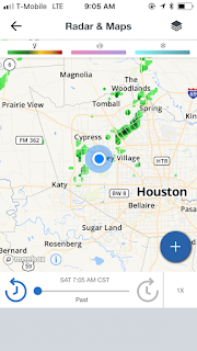
Houston, TX radar, during the mid-morning.
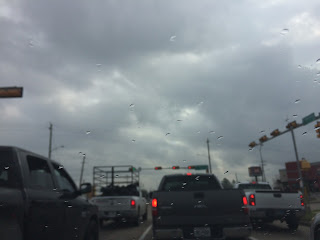
Northwest Houston, TX, during the mid-morning.
Northwest Houston, TX, during the late morning.
Houston, TX radar, during the mid-afternoon.
Houston, TX radar, during the late afternoon.
Houston, TX radar, during the late evening.
Houston, TX radar, during the early night.
Locations: Northwest and north Houston, TX.
Thoughts: Isolated bands of light to moderate and sometimes moderately heavy showers passed through the Houston, TX area, during the morning, afternoon, evening, and night. I witnessed some light to moderately heavy showers while driving with my friend to his parents house, during the late morning and early afternoon. The day was warm, mostly cloudy, and a little wet.
Area Forecast Discussion
Issued by NWS Houston/Galveston, TX
Versions: 1 2 3 4 5 6 7 8 9 10 11 12 13 14 15 16 17 18 19 20 21 22 23 24 25 26 27 28 29 30 31 32 33 34 35 36 37 38 3940 41 42 43 44 45 46 47 48 49 50
000
FXUS64 KHGX 180300
AFDHGX

Area Forecast Discussion
National Weather Service Houston/Galveston TX
900 PM CST Sat Feb 17 2018

.UPDATE...
The main update with the forecast tonight is to account for a
farther south progression of a cold front than previously
advertised. The KHGX radar shows this boundary stretching from
Vanderbilt to Bonney to Texas City and with the KHGX VAD wind
profiler showing very light winds above the surface doing little
to inhibit the southward movement, expect density differences to
drive this boundary off the coast within the next 2-3 hours. As
this front cleared the NWS Houston office, the temperature dropped
7 degrees within 30 minutes. Given these short-term trends, have
lowered low temperatures a few degrees into the upper 40s to near
60. A brief northerly wind shift associated with this boundary
moving off the coast may result in a brief respite in sea fog
(detailed in the marine section below) before winds veer to the
east sometime in the 3-6 AM timeframe.

SPC mesoanalysis shows the 925 MB front located farther north,
roughly north of Interstate 10, and convergence along this feature
may produce isolated to scattered showers through the overnight
hours north of a Columbus to Liberty line. Patchy radiation fog
may also be possible as dew point depressions decrease overnight
through mid morning, with best chances west of a Madisonville to
Katy to San Luis Pass line.

Huffman

&&

.MARINE...
A weak boundary continues to move toward the coast. Models are
not in great agreement but the latest HRRR shows the boundary
making it into the coastal waters before becoming diffuse later
tonight. North winds will develop in the wake of the front and
slightly drier air will likely make it into the waters. The drier
air will help erode the fog and the north winds should push any
remaining fog away from the coast. There should be some brief
improvement in visibility between 04-08z. East winds will develop
after midnight and become SE on Sunday. Fog is expected to
redevelop between 08-10z and persist intermittently through Sunday
morning. Onshore winds will strengthen Sunday afternoon as low
pressure over eastern Wyoming deepens. The low will push east on
Monday/Tuesday and drag a cold front into the state. The front
will probably stall and onshore winds will persist into Wednesday.
Periods of sea fog will likely hang around during the first half
of next as warm and moist air continues to flow over the cooler
shelf waters. The long S-SE fetch will bring slightly warmer water
toward the Upper Texas Coast and this may mitigate the threat for
dense sea fog early next week. 43

&&

.PREV DISCUSSION... /ISSUED 556 PM CST Sat Feb 17 2018/

AVIATION...
A weak front extended from about Liberty to downtown Houston and
then along the I-69 corridor to about Edna. Showers were beginning
to develop along this feature. Short term guidance shows the
boundary remaining nearly stationary and gradually becoming
diffuse. Low ceilings expected to develop areawide as deep mstr
builds beneath a capping inversion. LIFR/IFR cigs expected late
tonight into Sunday morning with a gradual improvement to MVFR by
afternoon. Sea fog will be an issue along the coast and visibility
will fall below a mile at times at KGLS and probably KLBX. 43

$$

&&

.PRELIMINARY POINT TEMPS/POPS...
College Station (CLL)      52  71  64  79  66 /  30  20  20  20  20
Houston (IAH)              57  74  65  78  67 /  30  20  20  20  10
Galveston (GLS)            60  71  64  73  66 /  20  20  20  20  10

&&

.HGX WATCHES/WARNINGS/ADVISORIES...
TX...NONE.
GM...Dense Fog Advisory until noon CST Sunday for the following
     zones: Coastal waters from Freeport to the Matagorda Ship
     Channel out 20 NM...Coastal waters from High Island to
     Freeport out 20 NM...Galveston Bay...Matagorda Bay.

&&

$$

Discussion...14
Aviation/Marine...43
Hazardous Weather Outlook
Hazardous Weather Outlook
National Weather Service Houston/Galveston TX
414 AM CST Sat Feb 17 2018

TXZ213-214-235>238-181300-
Brazoria-Chambers-Galveston-Harris-Jackson-Matagorda-
414 AM CST Sat Feb 17 2018

This hazardous weather outlook is for portions of Southeast Texas.

.DAY ONE...Today and Tonight

Sea fog could gradually make its way inland early this morning and
maybe again late tonight. Visibility could be reduced below 1 mile
at times, especially closer to the coastline.

.DAYS TWO THROUGH SEVEN...Sunday through Friday

Periods of sea fog can be expected into early next week. We will be
monitoring the potential for heavy rainfall in association with the
next weather system that approaches toward midweek.

.SPOTTER INFORMATION STATEMENT...

Spotter activation will not be needed.

$$


No comments:
Post a Comment