A fog advisory issued for the Houston, TX area, for the early monring, and the previous night,
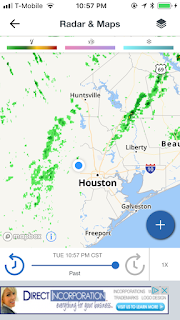
Houston, TX radar, during the early morning.
Northwest Houston, TX,, during the early morning.
Houston, TX radar, during the early afternoon.
Northwest Houston, TX, during the late evening.
Houston, TX, during the early night.
Houston, TX, during the late night.
Locations: Northwest Houston, TX.
Thoughts: Scattered light to moderate showers with some possible moderately heavy showers in the Houston, TX area, during the morning, afternoon, evening, and night. There was a moderately dense fog on my way to work in northwest Houston, TX, during the early morning. The day was a little cool, wet, and cloudy.
Area Forecast Discussion
Issued by NWS Houston/Galveston, TX
Home | Current Version | Previous Version | Text Only | Print | Product List | Glossary Off
Versions: 1 2 3 4 5 6 7 8 9 10 11 12 13 14 15 16 17 18 19 20 21 22 23 24 25 26 27 28 29 30 31 32 33 34 35 36 37 38 39 40 41 42 43 44 45 46 47 48 49 50
000
FXUS64 KHGX 070238
AFDHGX
Area Forecast Discussion
National Weather Service Houston/Galveston TX
838 PM CST Tue Feb 6 2018
.DISCUSSION...
At 8pm...the front stretches from roughly Columbus to Lufkin and
should continue to make very slow southward progress...probably
off the coast around 3 am or so. Look for periods of -ra (maybe
an embedded tstm) to persist along and behind the boundary tonight
and Wed. Texas Tech WRF seems to have a fairly good handle of the
precip depiction this far south. Think most everyone will eventually
see some rain, but more than likely just light nuisance coverage
compared to what some of the other guidance suggests. Fog has
mostly lifted across northern zones so have already cancelled the
advisory there. Coast remains socked in with sea fog, so will
maintain (and possibly extend) the dense fog advisory there until
the wind shift scatters it out. No major changes for the
update...mainly aligned grids w/ current wx and incorporated
trends noted above. 47
&&
.PREV DISCUSSION... /ISSUED 709 PM CST Tue Feb 6 2018/
AVIATION...
Messy TAFs will be continuing tonight...with fog/low
ceilings remaining an issue across SE TX through sunrise.
Conditions will be improving from the W/NW as cooler/drier air
filters into the area in the wake of a cold front. Scattered SHRAs
(and isolated TSRAs) will prevail ahead of this boundary, given
the warm/moist airmass already in place over the region. However,
the best instabilities for TSRA will likely be over our N/NE
counties (away from our TAF sites) so going to keep with the
VCSH/RA wording for now. Sea fog to remain the biggest issue for
GLS. 41
&&
.PRELIMINARY POINT TEMPS/POPS...
College Station (CLL) 38 45 35 57 44 / 70 50 10 10 10
Houston (IAH) 47 51 40 59 47 / 60 70 30 10 10
Galveston (GLS) 52 55 45 54 50 / 50 70 30 20 10
&&
.HGX WATCHES/WARNINGS/ADVISORIES...
TX...Dense Fog Advisory until 2 AM CST Wednesday for the following
zones: Brazoria...Chambers...Galveston...Matagorda.
GM...Dense Fog Advisory until 2 AM CST Wednesday for the following
zones: Coastal waters from Freeport to the Matagorda Ship
Channel out 20 NM...Coastal waters from High Island to
Freeport out 20 NM...Galveston Bay...Matagorda Bay.
&&
$$
Hazardous Weather Outlook
Hazardous Weather Outlook
National Weather Service Houston/Galveston TX
452 AM CST Tue Feb 6 2018

TXZ178-179-199-200-210>214-226-227-235>238-071100-
Austin-Brazoria-Chambers-Colorado-Fort Bend-Galveston-Harris-
Jackson-Liberty-Matagorda-Montgomery-Polk-San Jacinto-Waller-
Wharton-
452 AM CST Tue Feb 6 2018

This hazardous weather outlook is for portions of Southeast Texas..

.DAY ONE...Today and Tonight

Showers and isolated thunderstorms, and with areas of fog
sometimes dense will be possible today. A Dense Fog Advisory is in
effect through 10AM this morning.

.DAYS TWO THROUGH SEVEN...Wednesday through Monday

A cold front will bring more showers and thunderstorms on
Wednesday.

A storm system will approach the area Friday night and Saturday.
This system has the potential to produce locally heavy rain
Saturday morning. Another cold front moves through the region this
weekend.

.SPOTTER INFORMATION STATEMENT...

Spotter activation will not be needed.

$$


No comments:
Post a Comment