
Houston, TX radar, during the mid-morning.

Northwest Houston, TX, I think, during the mid-morning.

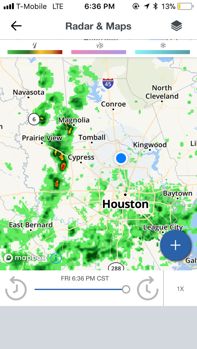
Tomball, TX, I think, during the mid-morning.

Houston, TX, during the mid-afternoon.

Southeast side of Houston, TX, near downtown Houston, TX, during the late evening.
Houston, TX, during the late evening.

Near, or maybe in the Woodlands, TX, during the early evening.

Near Tomball, TX, I think, during the early night.

Houston, TX, during the late night.

Northwest Houston, TX, during the late night.
Locations: Northwest, north, southeast, and the heights area of Houston, TX, Tomball, TX, Spring, TX, maybe Pasadena, TX, Woodlands, TX, and Klein, TX.
Thoughts: Isolated light to moderate showers during the morning and afternoon followed by scattered light to moderate and sometimes moderately heavy with maybe some heavy showers, during the evening and night. The day felt warm. No flooding.
Issued by NWS Houston/Galveston, TX
Versions: 1 2 3 4 5 6 7 8 9 10 11 12 13 14 15 16 17 18 19 20 21 22 23 24 25 26 27 28 29 30 31 32 33 34 35 36 37 38 3940 41 42 43 44 45 46 47 48 49 50
000
FXUS64 KHGX 100503
AFDHGX

Area Forecast Discussion
National Weather Service Houston/Galveston TX
1103 PM CST Fri Feb 9 2018

.DISCUSSION...
Current forecast looks on track. Development will continue over-
night as a series of shortwaves move across the region. Rainfall
totals so far have been light (generally right around a tenth of
an inch) but short-range models are keeping with more aggressive
shower/thunderstorm development overnight. Even with the contin-
ued lack of a discernible surface boundary, widespread rain with
locally heavier rains will remain possible...likely best at/near
the coast where moisture will be deepest. 41

&&

.PREV DISCUSSION... /ISSUED 719 PM CST Fri Feb 9 2018/

AVIATION...
S/W moving through the coastal waters with extremely moist air
blanketing the area leading to overcast lower ceilings. Showers
becoming widespread and these should continue through the night.
As next s/w approaches expect lift to increase across the region
and between 05-11z will likely see heavy showers mixing in with
the low ceilings. Thunderstorms look more likely for the Houston
area terminals southward. As the subtropical jet noses after
12-15z expect another round of showers with main circulation
departing the CLL area by 16z...VCSH issues will continue into the
early afternoon for the southern sites.

GLS area will likely experience dense fog for a few hours before
the showers and thunderstorms stir it up this evening.

Low to very low ceilings will likely return after 18z for most
sites.
45

&&

.PRELIMINARY POINT TEMPS/POPS...
College Station (CLL)      59  70  37  41  34 /  50  50  40  30  20
Houston (IAH)              61  72  48  51  39 /  80  80  50  40  30
Galveston (GLS)            60  69  54  58  45 /  80  80  50  40  40

&&

.HGX WATCHES/WARNINGS/ADVISORIES...
TX...Dense Fog Advisory until 7 AM CST Saturday for the following
     zones: Brazoria...Chambers...Galveston.

     Dense Fog Advisory until midnight CST tonight for the following
     zones: Jackson...Matagorda.

GM...Dense Fog Advisory until 11 PM CST this evening for the
     following zones: Coastal waters from Freeport to the
     Matagorda Ship Channel out 20 NM...Matagorda Bay.

     Dense Fog Advisory until 7 AM CST Saturday for the following
     zones: Coastal waters from High Island to Freeport out 20
     NM...Galveston Bay.

&&

$$
Hazardous Weather Outlook
Hazardous Weather Outlook
National Weather Service Houston/Galveston TX
359 PM CST Fri Feb 9 2018

TXZ163-164-176>179-195>200-210>214-226-227-235>238-101300-
Austin-Brazoria-Brazos-Burleson-Chambers-Colorado-Fort Bend-
Galveston-Grimes-Harris-Houston-Jackson-Liberty-Madison-Matagorda-
Montgomery-Polk-San Jacinto-Trinity-Walker-Waller-Washington-
Wharton-
359 PM CST Fri Feb 9 2018

This hazardous weather outlook is for portions of Southeast Texas.

.DAY ONE...This Afternoon and Tonight

Heavy rainfall will be possible late tonight into Saturday morning
mainly south of a Livingston to Conroe to Edna line. Rainfall totals
of 1 to 3 inches with isolated 4 inch amounts will be possible. Main
impacts will be localized street flooding on major roads and highways,
feeder roads and intersections.

.DAYS TWO THROUGH SEVEN...Saturday through Thursday

Heavy rainfall maybe ongoing Saturday morning will be coming to an
end later in the day with the threat for heavy rainfall moving off
to the east.

.SPOTTER INFORMATION STATEMENT...

Spotter activation may be needed late tonight through Saturday morning.

$$
No comments:
Post a Comment