
Houston, TX radar, during the mid-morning.
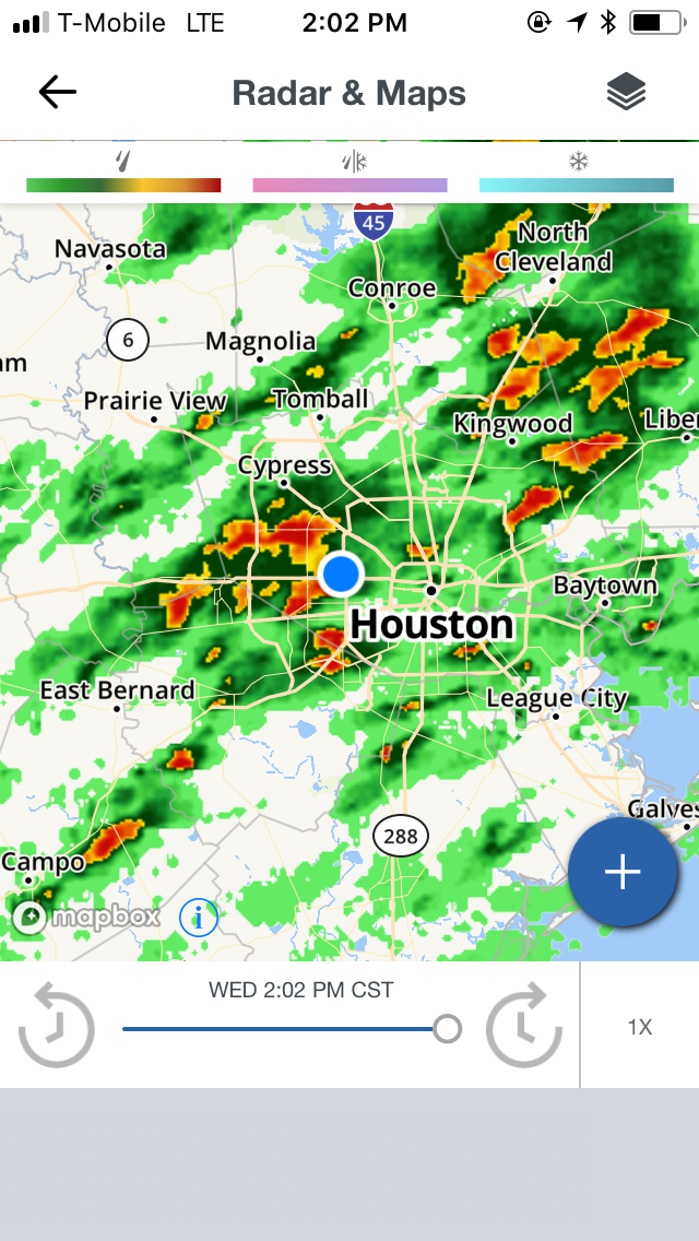
Houston, TX radar, during the early afternoon.

Northwest Houston, TX, during the early evening.

Houston, TX, during the late evening.
Locations: Northwest Houston, TX.
Thoughts: A regenerating line of light to moderate and moderately heavy, sometimes heavy to maybe really heavy thunderstorms passed through the Houston, TX area, during the Houston, TX area, during the morning, afternoon, and evening. The rain had stopped during the evening. The day was cold and wet.
Area Forecast Discussion
Issued by NWS Houston/Galveston, TX
Home | Current Version | Previous Version | Text Only | Print | Product List | Glossary Off
Versions: 1 2 3 4 5 6 7 8 9 10 11 12 13 14 15 16 17 18 19 20 21 22 23 24 25 26 27 28 29 30 31 32 33 34 35 36 37 38 39 40 41 42 43 44 45 46 47 48 49 50
000
FXUS64 KHGX 080342
AFDHGX
Area Forecast Discussion
National Weather Service Houston/Galveston TX
942 PM CST Wed Feb 7 2018
.DISCUSSION...
Cloud cover is scattering out across northern parts of the area
and guidance suggests most inland locations should see some peaks
of the stars tonight as drier air deepens thru the column. Areas
closer to the coast will probably see a broken cloud deck thru
most of the night. Temps are currently running a few degrees below
numerical guidance, but ongoing fcst already had this under
control. Other than to match current obs and trends with grids, no
changes were made to the ongoing forecast. 47
&&
.PREV DISCUSSION... /ISSUED 610 PM CST Wed Feb 7 2018/
AVIATION...
While the bulk of the stronger storms along the coast
are moving off to the E/SE, radar is indicating that some bands
of light RA are still developing/moving into the northern parts of
the area. As such will be keeping at least the mention of VCSH in
for most of the TAFS through the evening. Otherwise, the strong
inversion in the wake of this front will help to keep CIGS low
through the overnight hours even with the encroaching drier/colder
air...especially for the central and southern sites. Northern
sites (CLL and UTS) will see clear skies as the back edge of the
cloud deck nudges south shortly...but MVFR/IFR ceilings could
linger across the rest of SE TX until morning. Will keep with the
trend of improving conditions tomorrow afternoon for all but
LBX/GLS. 41
&&
.PRELIMINARY POINT TEMPS/POPS...
College Station (CLL) 34 57 45 65 55 / 10 10 20 30 50
Houston (IAH) 39 58 47 65 57 / 20 10 20 40 60
Galveston (GLS) 43 54 54 63 59 / 30 20 30 40 70
&&
.HGX WATCHES/WARNINGS/ADVISORIES...
TX...NONE.
GM...Small Craft Advisory until midnight CST tonight for the
following zones: Coastal waters from Freeport to the
Matagorda Ship Channel out 20 NM...Coastal waters from High
Island to Freeport out 20 NM...Matagorda Bay.
SMALL CRAFT SHOULD EXERCISE CAUTION until midnight CST tonight
for the following zones: Galveston Bay.
Small Craft Advisory until 4 AM CST Thursday for the following
zones: Waters from Freeport to the Matagorda Ship Channel
from 20 to 60 NM...Waters from High Island to Freeport from
20 to 60 NM.
&&
$$
Hazardous Weather Outlook
Hazardous Weather Outlook...CORRECTED
National Weather Service Houston/Galveston TX
316 PM CST Wed Feb 7 2018

TXZ163-164-176>179-195>200-210>214-226-227-235>238-081300-
Austin-Brazoria-Brazos-Burleson-Chambers-Colorado-Fort Bend-
Galveston-Grimes-Harris-Houston-Jackson-Liberty-Madison-Matagorda-
Montgomery-Polk-San Jacinto-Trinity-Walker-Waller-Washington-
Wharton-
316 PM CST Wed Feb 7 2018

This hazardous weather outlook is for portions of Southeast Texas.

.DAY ONE...This Afternoon and Tonight

Shower and isolated thunderstorm coverage will decrease late this
afternoon and on through the overnight hours.

.DAYS TWO THROUGH SEVEN...Thursday through Tuesday

A storm system will approach the area Friday afternoon through Saturday
and will bring increasing shower and thunderstorm chances. Another cold
front will move through the region late Saturday night or early Sunday
morning.

.SPOTTER INFORMATION STATEMENT...

Spotter activation will not be needed.

$$
No comments:
Post a Comment