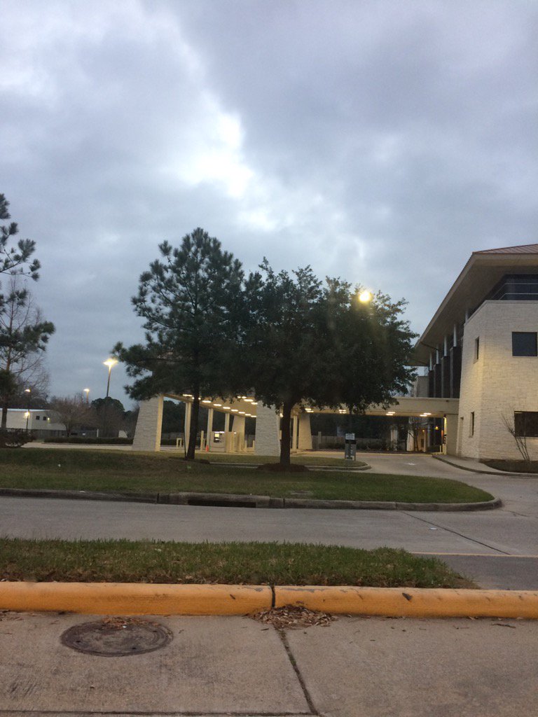
Northwest Houston, TX during the early morning.
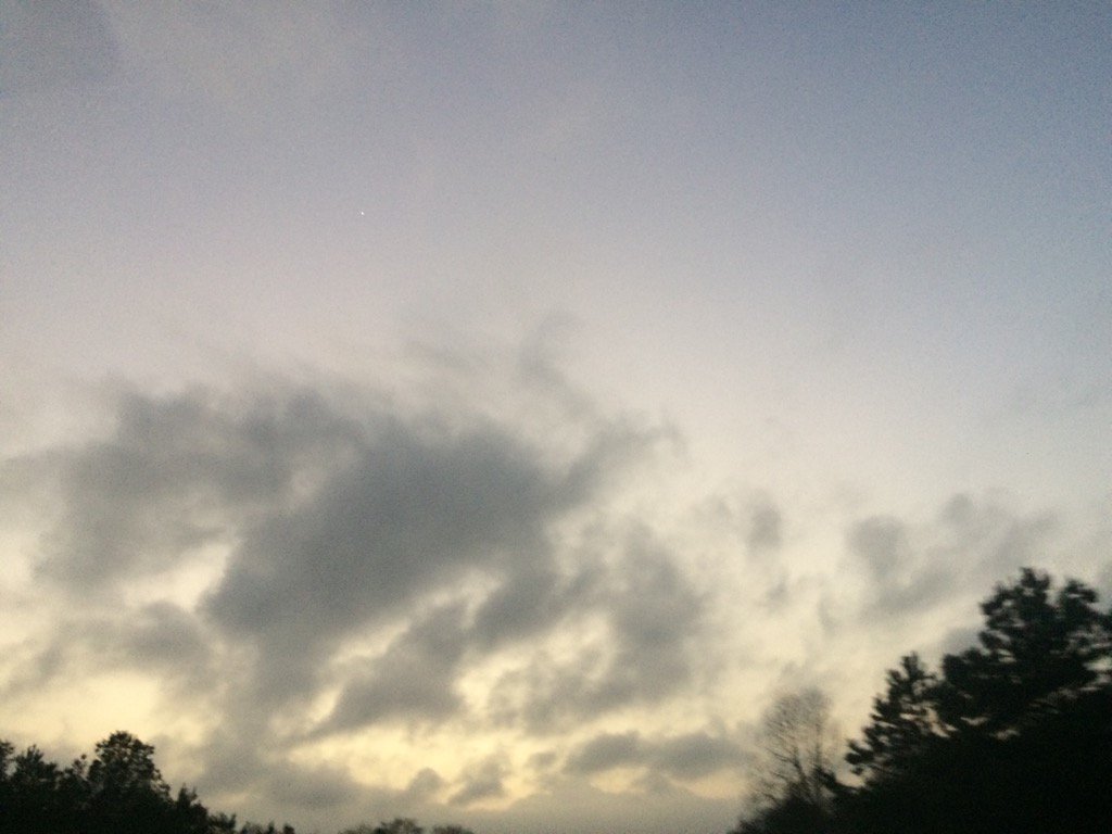
West Houston, TX during the late evening.
Notes: Big to small, bright white, light to dark grey, and light to dark blueish grey, thick, flat, puffy, low stratus clouds looked to cover the whole sky in northwest and west Houston, TX during the early morning. Big to small, bright white, light to dark grey, and light to dark blueish grey, thick, flat, puffy, low stratus clouds looked to cover the whole sky in west Houston, TX during the mid and late morning. Big to small, bright white, light to dark grey, and maybe some light to dark blueish grey, thick, flat, puffy, low stratus clouds looked to have started to cover only most of the sky in west Houston, TX, sometime during the mid, or maybe early afternoon. Big to small, bright white, light to dark grey, and maybe some light to dark blueish grey, thick, flat, puffy, low stratus clouds looked to cover most of the sky in west Houston, TX during the mid and late afternoon and early evening. Big to small, bright white, light to dark grey, and maybe some light to dark blueish grey, thick, flat, puffy, low stratus clouds looked to cover most of the sky in northwest and west Houston, TX during the late evening. Big to small, bright white and light to dark grey, thick, flat, puffy, low stratus clouds looked to cover most of, or maybe the whole the sky in northwest Houston, TX during the early night. The wind speeds looked to be calm in northwest and west Houston, TX during the early morning. The wind speeds looked to be calm with some moderate gusts in west Houston, TX during the mid-morning. The wind speeds looked to be calm with moderate and moderately strong gusts in west Houston, TX during the late morning and early and mid-afternoon. The wind speeds looked to be calm with moderate and moderately strong gusts with some really strong gusts (20-25 mph) in west Houston, TX during the late afternoon and early evening. The wind speeds looked to be calm with moderate and moderately strong gusts in northwest and west Houston, TX during the late evening. The wind speeds looked to be calm with moderate gusts and maybe some moderately strong gusts in northwest Houston, TX during the early night. It felt cool in northwest and west Houston, TX during the early morning. It started to feel warm in west Houston, TX during the mid-morning. It felt warm in west Houston, TX during the late morning. It felt warm, almost very warm in west Houston, TX during the afternoon. It felt warm in west Houston, TX during the evening. It felt warm in northwest Houston, TX during the late evening and early night. There were no advisories, watches, or warnings issued for the Houston, TX area, that I know of. There was a 0 to 20 percent chance for rain for the Houston, TX area, during the day. The low temps were in the 60's, or maybe 50's and highs were in the high 70's and maybe low 80's, for the Houston, TX area.
Summary: The day was warm and dry. I didn't see, or hear any rain drops, during anytime of the day. I did feel some possible rain drops in west Houston, TX, where I work, during the early, mid, and late afternoon, and maybe early evening. I saw some isolated light showers near and maybe in the Houston, TX area, on the radar, during the morning, afternoon, evening. and maybe night.
Thoughts: Well the clouds have started to roll in, but no rain yet. More record highs to break tomorrow and maybe Sunday. Also there is a possible severe weather event on Tuesday. For the Houston, TX area.
Area Forecast Discussion
Issued by NWS Houston/Galveston, TX
Issued by NWS Houston/Galveston, TX
Versions: 1 2 3 4 5 6 7 8 9 10 11 12 13 14 15 16 17 18 19 20 21 22 23 24 25 26 27 28 29 30 31 32 33 34 35 36 37 3839 40 41 42 43 44 45 46 47 48 49 50
000
FXUS64 KHGX 110241
AFDHGX

Area Forecast Discussion
National Weather Service Houston/Galveston TX
841 PM CST Fri Feb 10 2017

.UPDATE...
The general forecast philosophy is on track, but required a few
tweaks for observations. Tonight looks likely to end up slightly
warmer than originally thought, which will be further help in
seeing a very warm day tomorrow in spite of clouds.

Luchs

&&

.PREV DISCUSSION... /ISSUED 549 PM CST Fri Feb 10 2017/

AVIATION...
Still expecting a majority of the area to have MVFR and possible IFR
ceilings overnight. Look for south winds generally in a 6 to 10 knot
range inland and 10 to 13 knots at the coast. Do not anticipate any
significant fog development overnight either. Slow ceiling improvement
is anticipated tomorrow with the possibility for a majority of the area
staying MVFR all day. We`ll also be seeing strengthening/gusty south
to south southwest winds during the day tomorrow.  42

PREV DISCUSSION... /ISSUED 320 PM CST Fri Feb 10 2017/

DISCUSSION...
At 2 PM, surface high pressure has moved east of the region and
was located over South Carolina. A trough of low pressure was
located over the western high plains and the flow between these
two systems was bringing abundant low level moisture into SE TX. A
few light rain showers were moving up the coast but amounts have
generally been a Trace. Skies are expected to remain mostly cloudy
overnight as fcst soundings show the sfc-900 mb layer saturated
with a strong cap in place and very dry air above the cap. cloudy
skies tonight will help insulate and since winds are not expected
to fully decoupled, feel overnight min temps will remain on the
warm side with possible some record high mins by Saturday morning.
Saturday will start out unseasonably warm so it won`t take much in
the way of heating to get temperatures into the lower 80`s. Fcst
soundings show a lot of dry air above 900 mb with moisture trapped
beneath the cap keeping skies mostly cloudy. Don`t think moisture
levels are deep enough to generate precipitation and will keep
things dry for now. Saturday night looks similar to tonight with
extensive cloud cover as moisture remains capped beneath a strong
cap. A weak boundary will approach SE TX late Sunday afternoon but
the warm start to Sunday should once again allow max temps to warm
to near 80 before the boundary attempts to cross the region. Fcst
soundings show a strong cap in place in the morning with the cap
weakening in the aftn. Pw values also increase from under an inch
Sunday morning to 1.25 inches by Sunday evening. Will show a
gradual increase in PoPs late Sunday afternoon into Sunday night
over the north but the south still looks too capped for much in
the way of showers. Weak isentropic upglide is expected to develop
in the wake of the front Sunday night with some patchy light rain
developing. Fcst soundings show better saturation over the north
with drier air above 850 mb over the south so feel the higher rain
chances favors the northern half of the CWA. The moisture profile
on Monday still shows pockets of dry air but the 500 mb flow
becomes increasingly amplified and there will likely be some weak
disturbances embedded in the SW flow aloft so will maintain low
rain chances for Monday with the higher chances again over the
north. SREF ensembles still favor some sea fog early Saturday and
agai Sunday morning. Not sure the sfc wind trajectory is all that
favorable but will continue to mention patchy fog over the near
shore waters and adjacent bays through the weekend.

Here are the records (record highs and record high mins) for the
4 primary climate sites for Saturday and Sunday:

                 02/11                     02/12

Houston        82  1999                  84  1922
               66  1957                  65  1952

Hou Hobby      80  1999                  82  1962
               65  1984                  63  1952

Col Station    84  1922                  87  1922
               67  1984                  68  1922

Galveston      77  1999                  75  1957
               67  1876                  66  1884

An upper level low will drop into S AZ Mon night and head east on
Tuesday. Upper level winds will become increasing diffluent Monday
night into Tuesday and moisture levels begin to increase reaching
a peak of 1.55 inches by late Tuesday aftn. A surface low is
expected to late Monday night over South Central Texas and this
feature will move ENE across SE TX on Tuesday. The position of the
low is critical to the type of weather SE TX will receive. At this
time, it appears the SE half of the region will lie in the warm
sector with a weak boundary lying E-W across the area. Way too
soon to get alarmed, but fcst soundings reveal Sfc-1km helicity
values of 311 m2/s2 and sfc-2km values over 400. Would not be
surprised if some of the storms in the warm sector produced a few
tornadoes. CAPE is low and under 500 J/Kg, LI`s progged at -2 and
lapse rates are benign so not all the severe weather parameters
are in phase but the shear is impressive. Soundings also show a
saturated profile so would expect some of the stronger storms to
produce locally heavy rain. They system will move east relatively
rapidly on Wednesday but some wrap around clouds and moisture will
keep low rain chances in the forecast along with some slightly
cooler temperatures. Slightly warmer temperatures are expected for
the end of next week as sunshine returns.

MARINE...
A relatively tight onshore pressure gradient will exist between
eastern U.S. seaboard high pressure and lowering Rocky Mountain lee
pressure over the weekend. This will produce periods of caution
level onshore winds over the far Gulf waters. Sea heights will
generally remain within an average 3 to 5 feet...6 feet over areas
that experience a longer duration 15 to 20 knot southerly fetch.
With the return of a warm and more humid air mass...the threat for
early day weekend marine fog will exist. Likely patchy fog Saturday
but possibly more widespread and dense Sunday morning.  The approach
of an upper level storm system and its associated surface trough of
low pressure will introduce periods of Monday rain (showers). The
eastern passage of this system will heighten the probabilities of
more widespread showers and thunderstorms late Tuesday into
Wednesday. 31

&&

.PRELIMINARY POINT TEMPS/POPS...
College Station (CLL)      79  65  81  66  77 /  10  10  10  10  20
Houston (IAH)              75  67  82  68  81 /  20  10  10  10  20
Galveston (GLS)            73  66  75  66  74 /  20  10  10  10  20

&&

.HGX WATCHES/WARNINGS/ADVISORIES...
TX...NONE.
GM...SMALL CRAFT SHOULD EXERCISE CAUTION through Sunday morning for
     the following zones: Waters from Freeport to the Matagorda
     Ship Channel from 20 to 60 NM...Waters from High Island to
     Freeport from 20 to 60 NM.

&&

$$

Discussion...25
No comments:
Post a Comment