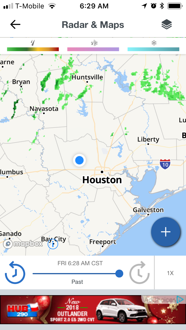
Houston, TX radar, during the early morning.

Northwest Houston, TX, during the early morning.

Houston, TX radar, during the early afternoon.

Northwest Houston, TX, during the early afternoon.

Houston, TX radar, during the early evening.

West Houston, TX, during the early evening.
Summary: The day was mostly warm, mostly cloudy, and a little wet. Isolated light to moderate rain showers and drizzle with maybe some moderately heavy showers and drizzle were scattered in and around the Houston, TX area, during the morning, afternoon, evening, and night. I saw and felt a few rain drops/drizzle, where I was in northwest Houston, TX, during the morning and early and mid-afternoon. More widespread light to moderate drizzle and a few occasional moderately heavy showers and drizzle began falling, where I was in northwest Houston, TX, during the late afternoon, and continued off and on through the late night. I think I saw some light to moderate drizzle, when I went to pick up my mom from my dad's store in west Houston, TX, during the early evening. Big, thick stratus clouds looked to cover the whole sky and sometimes only most of the sky, during the morning, afternoon, evening, and night. The wind speeds were gentle with moderate to moderately strong gusts, during the morning and afternoon, with some really strong 20 to 25 and maybe even 30+ mph gusts, during the evening and night. It felt warm during the morning and afternoon. It started to feel cool, during the early evening. It started to feel very cool, during the late evening. It started to feel very cold, during the early night. It felt very cold, during the late night. There were no watches, warnings, alerts, advisories, or weather statements/outlooks issued for the Houston, TX area, that I know of. The low temperatures looked to be in the mid to low 40's and the high temperatures looked to be in the mid to high 70's with maybe some low 80's, for the Houston, TX area.
Houston, TX Storm Summary: Isolated light to moderate rain showers and drizzle with maybe some moderately heavy showers and drizzle were scattered in and around the Houston, TX area, during the morning, afternoon, evening, and night. I didn't see, or hear about any reports of flooding, or damage caused by the weather, in any of the locations in the Houston, TX area, during anytime of the day.
My Storm Summary: I saw and felt a few rain drops/drizzle, where I was in northwest Houston, TX, during the morning and early and mid-afternoon. More widespread light to moderate drizzle and a few occasional moderately heavy showers and drizzle began falling, where I was in northwest Houston, TX, during the late afternoon, and continued off and on through the late night. I think I saw some light to moderate drizzle, when I went to pick up my mom from my dad's store in west Houston, TX, during the early evening. I saw lots of leaves and twigs with some big sticks, that had fallen from trees, as the cold front was pushing through my neighborhood, during the night. I just saw some partly wet roads and ground, but no puddles. I didn't see any flashes of lightning, or hear any rumbles of thunder. I didn't see any flooding, or damage caused by the weather.
Locations: Northwest and west Houston, TX.
Thoughts: I was really enjoying the warm weather, but it looks like it is going to be cold for a lirrle while. That's ok!
Area Forecast Discussion
Issued by NWS Houston/Galveston, TX
Issued by NWS Houston/Galveston, TX
Versions: 1 2 3 4 5 6 7 8 9 10 11 12 13 14 15 16 17 18 19 20 21 22 23 24 25 26 27 28 29 30 31 32 33 34 35 36 37 38 3940 41 42 43 44 45 46 47 48 49 50
000
FXUS64 KHGX 230528
AFDHGX

Area Forecast Discussion
National Weather Service Houston/Galveston TX
1128 PM CST Fri Dec 22 2017

.AVIATION...
The cold front has cleared KGLS leaving scattered showers and low
ceilings in its wake. Ceilings will continue to gradually improve
from NW to SE throughout the night, with KCLL already back up to
VFR. All sites should be VFR by around mid-morning. Breezy NW
winds are expected in the wake of the front, with the gustiness
hanging around about as long as the low ceilings. NW winds are
expected to continue through most of the taf period before
gradually turning around to onshore again overnight Saturday
night. 11

&&

.PREV DISCUSSION... /ISSUED 633 PM CST Fri Dec 22 2017/

UPDATE...
Cold front is sweeping through Southeast Texas, with a temperature
gradient of up to 30 degrees across the front. This has required a
little retooling of the temperature grids to better match with
obs. The big picture forecast is on track, so there`s little to
do beyond capturing the temperature gradient more accurately and
tweaking PoPs slightly as well.


PREV DISCUSSION... /ISSUED 249 PM CST Fri Dec 22 2017/

DISCUSSION...
A cold front as of 2 pm was through College Station and Crockett.
On north side of front temperatures were in the 40s and
50s...south of the front 70s to near 80. This front is progged to
push from NW to SE this afternoon and evening reaching the coast
between 9 and 10 pm tonight. Observed and model soundings show
significant cap limited precipitation to shallow convection,
showers from instability beneath the cap. There have been a few
lightning strikes this afternoon north of the front from elevated
convection. Can rule out an isolated rumble of thunder near and
behind the front but in general expect just rain showers with this
system. Will also see that 20 to 25 degree drop in temperatures as
well. There will be a small window for sea fog ahead of the front
as winds speeds decrease and winds become more southwesterly but
not confident of this. Have kept that possibility in between 6 and
9 pm or 00 to 03 UTC.

For Saturday through Monday...Christmas Day...expect cool...dry
conditions with abundant sunshine with high pressure building in
at the surface and zonal flow aloft. Coldest night would seem to
be Christmas Eve when could see a light freeze across northern
sections but nothing too extreme.

For Tuesday through Thursday of next week rain chances increase
again with more of an easterly wind at low levels...and hint of a
coastal trough and lift from right rear quadrant of intensifying
upper level jet. Not expecting anything heavy but more of a band
of relatively light stratiform rain as air mass still cool and
stable.

18

MARINE...
A cold front will cross the coast tonight. Ahead of the front, a brief
period of sea fog will be possible this evening. The threat for fog
will end once the front moves through the coastal waters sometime
between 03z and 06z. Winds will increase quickly behind the front
and an SCA will be required for the offshore waters. Slightly
lighter winds expected over the bays and near shore waters and will
issue a SCEC for those areas. The moderate to strong offshore flow
will push water out of the bays and some brief/minor low water
conditions could be possible early Saturday. Conditions are expected
to improve by late Saturday as surface high pressure slides into
Southeast Texas. Offshore flow will gradually veer to the east by
Christmas with the departure of the surface high, with winds
flirting with caution flag criteria at times as this happens. A
persistent E-NE wind will develop mid week and tide levels will
increase in response to the prolonged E-NE fetch. 43

&&

.PRELIMINARY POINT TEMPS/POPS...
College Station (CLL)      38  55  38  59  35 /  40   0   0   0   0
Houston (IAH)              44  57  40  63  39 /  60  10   0   0   0
Galveston (GLS)            49  56  49  61  46 /  60  10   0   0   0

&&

.HGX WATCHES/WARNINGS/ADVISORIES...
TX...NONE.
GM...Small Craft Advisory until 6 AM CST Saturday for the following
     zones: Coastal waters from Freeport to the Matagorda Ship
     Channel out 20 NM...Coastal waters from High Island to
     Freeport out 20 NM...Galveston Bay...Matagorda Bay...Waters
     from Freeport to the Matagorda Ship Channel from 20 to 60
     NM...Waters from High Island to Freeport from 20 to 60 NM.

&&

$$

Discussion...25
Aviation/Marine...11
No comments:
Post a Comment