
Northwest Houston, TX, during the early morning.

West Houston, TX, during the early afternoon.


Northwest Houston, TX, during the early evening.

Houston, TX radar, during the early evening.
Near Brenham, TX, during the early night.

Houston, TX radar, during the early night.

Updated Houston, TX forecast, during the early night. They were predicting snow!

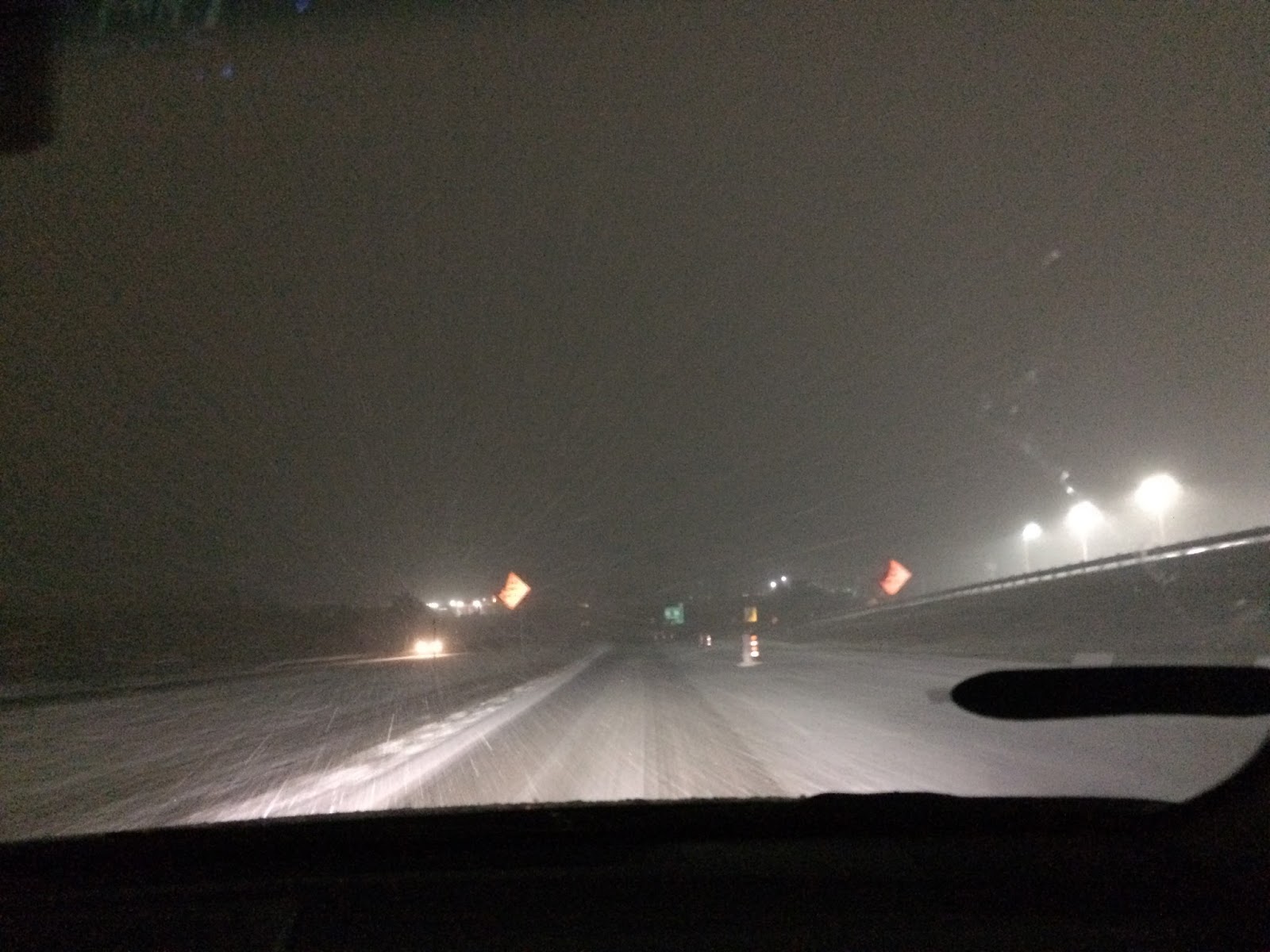
The weathercondition, at my house, in northwest Houston, TX, during the late night.

Houston, TX radar, during the late night.

The top of my car, at my house in northwest Houston, TX, during the late night.
Summary: The day was very cold, wet, and cloudy. Mostly light with some moderate to moderately heavy rain fell in most of, if not all of the Houston, TX area, during the morning, afternoon, evening, and early and maybe late night Mostly light with some moderate to moderately heavy rain mixed in with some ice pellets/sleet/ and maybe a few snow flurries started to fall in some locations in the Houston, TX area, during the early night. Light to moderate snow started to fall in some locations, if not all of the locations in the Houston, TX area, during the late night. I saw mostly light rain with some off and on moderate to moderately heavy rain showers, where I was in west and northwest Houston, TX, during the morning, afternoon, evening, and early night. I saw a winter mix and then light to moderate and then moderately heavy snow, when I was riding in the car with my older brother in Brenham, TX, during the early night. Light to moderate and sometimes moderately heavy snow followed my brother and me back to our house in northwest Houston, TX, during the late night. Low stratus clouds looked to cover the whole sky, in northwest and west Houston, TX, during the morning, afternoon, evening, and night. Low stratus clouds, looked to cover most of the sky, on our way to and at, and then on our way back from Brenham, TX, during the night. The wind speeds looked to be calm with gentle to moderate gusts and some moderately strong gusts with some occasional really strong 20 to 25 mph gusts. It felt very cold, during the morning and evening, in Houston, TX. It felt cold, during the afternoon, in Houston, TX. It felt very cold in Houston and Brenham, TX, during the night. There were no watches, warnings, alerts, advisories, or weather statements/outlooks issued for the Houston, TX area, that know of. There was a Winter Weather Advisory and a Freeze Warning issued for the Brenham, TX area, during the night.There was a Freeze Warning, or maybe Freeze Watch issued for the Hempstead, TX area, during the late and maybe early night. The temperatures were in the mid to low 30's on the way to Brenham, TX, during the early night. The temperatures were in the low 30's at Brenham, TX, during the early and late night. The temperatures were in the low 30's on the way back to Houston, TX, from Brenham, TX, during the late night. The low temperatures were in the low 30's and the high temperatures were in the low 40's, with maybe some mid 40's, for the Houston, TX area.
Southeast, TX Storm Summary: Mostly light with some moderate to moderately heavy rain fell in most of, if not all of the Houston, TX area, during the morning, afternoon, evening, and early and maybe late night Mostly light with some moderate to moderately heavy rain mixed in with some ice pellets/sleet/ and maybe a few snow flurries started to fall in some locations in the Houston, TX area, during the early night. Light to moderate snow started to fall in some locations, if not all of the locations in the Houston, TX area, during the late night. I didn't hear about any reports of flooding, or storm damage caused by the weather, in any of the locations that my brother and me went through in southeast Houston, TX. There was some possible icing on the roads when my brother and me were driving on the way to, in, and on the way back from Brenham, TX on 290.
My Storm Summary: I saw mostly light rain with some off and on moderate to moderately heavy rain showers, where I was in west and northwest Houston, TX, during the morning, afternoon, evening, and early night. I saw a winter mix and then light to moderate and then moderately heavy snow, when I was riding in the car with my older brother in Brenham, TX, during the early night. Light to moderate and sometimes moderately heavy snow followed my brother and me back to our house in northwest Houston, TX, during the late night. I saw wet roads, puddles, and wet ground, in the Houston, TX area, during the morning, afternoon, evening, and early night. I saw wet roads, puddles, wet ground, snow on the ground and roads with ice in the Brenham, TX area, during the early and late night. I saw some snow starting to accumulate on the roads, cars, and ground, in the Houston, TX area, during the late night. There might have also been some ice accumulating on the roads in the Houston, TX area, during the late night. I didn't see any flooding, or storm damage caused by the weather, in the Houston, TX, or Brenham, TX area. I didn't see any lightning, or hear any rumbles of thunder, in any of the areas that I was in, in southeast, TX, during anytime of the day.
Locations: Northwest and west Houston, TX, Brenham, TX, Hempstead, TX, and maybe Katy, TX.
Thoughts: I was not expecting to see that much snow, of at all. So I was very happy to see it. I hadn't seen snow falling, since January of 2013. I did see snow on the ground earlier this year in January. But I always think it is fun to see snow and I never know when I will get to see snow again, so I enjoyed it!
Area Forecast Discussion
Issued by NWS Houston/Galveston, TX
Versions: 1 2 3 4 5 6 7 8 9 10 11 12 13 14 15 16 17 18 19 20 21 22 23 24 25 26 27 28 29 30 31 32 33 34 35 36 37 38 3940 41 42 43 44 45 46 47 48 49 50
000
FXUS64 KHGX 080351
AFDHGX

Area Forecast Discussion
National Weather Service Houston/Galveston TX
951 PM CST Thu Dec 7 2017

.UPDATE...
Winter Weather Advisory in effect across the north areas for snow
and icy roads.

Specifically for the Caldwell to College Station to Madisonville
area. Brief heavy snow occurred earlier this evening...no more
significant snow is expected for those areas that had the
heaviest snow. 4-6 inches observed in and around the College
Station area per social media and KBTX. Stressing that although
the precip may be over there the impacts may be getting worse.
Snow packed roads are going to get icy as well as bridges. Texas
Department of Transportation has already begun treating. Traffic
impacts may be significant overnight/early Friday. Temperatures
will struggle to get above freezing until probably 9 am with all
the snow on the ground there.

Elsewhere...the band of intense snow that was over Caldwell to
College Station to near Madisonville showing some signs of
weakening and sagging southward. Temperatures beneath the band are
running 31 to 32 thanks to wet-bulbing and is helping to account
for the accumulations. To the north of the band temperatures 35-37
and south of the band 39-42 (across the Houston area). The RAP
and HRRR have been doing a good job tonight in capturing the
focused nature of the heavier precip near CLL. GRK radar clearly
showing the drier air infiltrating and the precipitation weakening
and shifting southward. Based on current guidance looking like
two bands are likely to develop a weaker band along the southern
edge of the advisory with a second more intense band translating
up the coast and parking over the coastal counties from Jackson to
Brazoria county. AMDAR soundings (HOU/IAH) all showing the
transition over to freezing around 1700ft with freezing profile
above. As the next band develops think that rain/snow mix will
predominate across the southern areas gradually transitioning over
to mainly snow. Temperatures are forecast to remain at or above
freezing to the south of the advisory including the Houston Metro
area so the snow should melt on contact with roads. Could car
roof/grass/home rooftops accumulate a little snow yes. Areas
across Matagorda and Brazoria county might bottom out at 33 or
even 32 for an hour or two during the peak intensity but then
rebound so still just grassy areas with any accumulation.


45

&&


PREV DISCUSSION... /ISSUED 619 PM CST Thu Dec 7 2017/

AVIATION...
A band of light rain with embedded pockets of snow and sleet has
set up near CLL and UTS with light rain continuing near
IAH/SGR/HOU/LBX/GLS. Expect the wintry mix to continue near CLL
and UTS through 03Z and provide periods of IFR to MVFR ceilings
and visibilities before shifting south between 03-06Z as drier air
arrives and an upper level jet streak slides across the lower
half of region from Mexico. While VFR is expected to prevail,
heavier rain/snow bands will again result in IFR to MVFR ceiling
and visibility restrictions for the Houston/Sugar Land and coastal
terminals. Greatest potentials for terminal impacts to
Houston/Sugar Land is expected to be between 04-11Z, persisting
slightly longer along the coast before precipitation shifts south
of the coastal terminals by 14-16Z with VFR ceilings continuing to
lift and scatter by the end of the TAF period. Northerly winds in
the 8-15 knot range will continue inland tonight, with winds in
the 10-20 knot range for LBX and GLS. Stronger gusts near 30 knots
will be possible at GLS through Friday morning. Expect winds to
fall below 10 knots at inland terminals by the end of the TAF
period as surface high pressure builds into the region.

Huffman

$$

&&

.PRELIMINARY POINT TEMPS/POPS...
College Station (CLL)      29  50  32  60  34 / 100   0   0   0   0
Houston (IAH)              33  48  33  59  37 /  70  10   0   0   0
Galveston (GLS)            38  48  42  59  46 /  80  30   0   0   0

&&

.HGX WATCHES/WARNINGS/ADVISORIES...
TX...Freeze Warning until 7 AM CST Friday for the following zones:
     Austin...Brazos...Burleson...Colorado...Grimes...Houston...
     Liberty...Madison...Montgomery...Polk...San Jacinto...
     Trinity...Walker...Waller...Washington.

     Winter Weather Advisory until 9 AM CST Friday for the following
     zones: Brazos...Burleson...Grimes...Houston...Madison...
     Trinity...Walker...Washington.

GM...Small Craft Advisory until 6 AM CST Friday for the following
     zones: Coastal waters from Freeport to the Matagorda Ship
     Channel out 20 NM...Coastal waters from High Island to
     Freeport out 20 NM...Galveston Bay...Matagorda Bay.

     Gale Warning until 6 AM CST Friday for the following zones:
     Waters from Freeport to the Matagorda Ship Channel from 20
     to 60 NM...Waters from High Island to Freeport from 20 to
     60 NM.

&&

$$

Discussion...45
No comments:
Post a Comment