

Houston, TX radar, during the early morning, before sunrise.


Northwest Houston, TX, during the early morning.
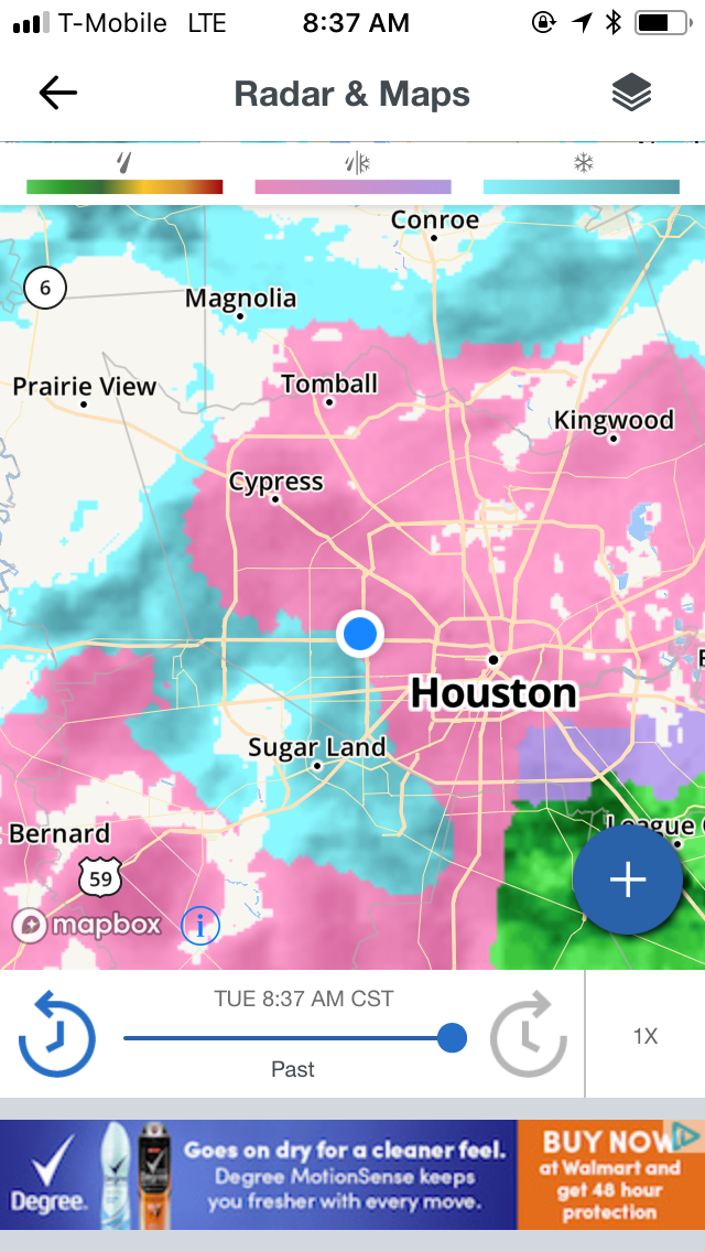

Houston, TX radar, during the mid-morning.

Houston, TX radar, during the early afternoon.


Northwest Houston, TX, during the early afternoon.

Weather forecast for the Houston, TX area, during the early afternoon.

Houston, TX radar, during the early evening.


Houston, TX radar, during the early night.
Summary: The day was freezing, icy, and cloudy. Freezing rain, sleet, and some snow flakes started to fall in the Houston, TX area, during the early morning and continued to fall through the early night. I started to see light to moderate, sometimes moderately heavy freezing rain/sleet at my house and on my way to work in northwest Houston, TX, during the early morning. Light to moderate, sometimes moderately heavy freezing rain/sleet continued to fall where I work and at my house in northwest Houston, TX, during the mid and late morning and through the afternoon. Light to maybe sometimes moderate snow flakes were falling at my house, during the evening. The freezing rain.sleet/snow looked to have stopped with maybe a few light drops/dusting, at my house in northwest Houston, TX, during the early night. The sky looked to be completely covered in gray and blue stratus clouds, during the morning, afternoon, evening, and night. The wind speeds looked to be gentle with moderate to moderately strong gusts and some really strong 25 to 30, and maybe some 40+ mph gusts. It felt freezing during the morning, afternoon, evening, and night. There was a Winter Storm Warning, then Winter Storm Advisory, Wind Chill Advisory, Hard Freeze Warning, and a Hazardous Weather Outlook issued for the Houston, TX area, by NOAA. The low temperatures looked to be in the low to mid 20's and the high temperatures looked to be in the high 30's, for the Houston, TX area. The high 30's were during the early morning, before sunrise, before the front passed through the Houston, TX area.
Houston, TX Storm Summary: Freezing rain, sleet, and some snow flakes started to fall in the Houston, TX area, during the early morning and continued to fall through the early night. I didn't hear about any flooding, or damage caused by the weather, to any of the locations in the Houston, TX area, during anytime of the day. The streets of Houston, TX were icing over throughout the day. Trucks were out trying to de-ice the roads.
My Storm Summary: I started to see light to moderate, sometimes moderately heavy freezing rain/sleet at my house and on my way to work in northwest Houston, TX, during the early morning. Light to moderate, sometimes moderately heavy freezing rain/sleet continued to fall where I work and at my house in northwest Houston, TX, during the mid and late morning and through the afternoon. Light to maybe sometimes moderate snow flakes were falling at my house, during the evening. The freezing rain.sleet/snow looked to have stopped with maybe a few light drops/dusting, at my house in northwest Houston, TX, during the early night. The roads were icy and wet, where I was, during the morning, afternoon, evening, and night. I didn't see any lightning strikes, or hear any rumbles of thunder. I didn't see any flooding, or damage caused by the weather, where I was, during the day.
Locations: Northwest Houston, TX.
Thoughts: Lots of ice in Houston, TX!
Area Forecast Discussion
Issued by NWS Houston/Galveston, TX
Versions: 1 2 3 4 5 6 7 8 9 10 11 12 13 14 15 16 17 18 19 20 21 22 23 24 25 26 27 28 29 30 31 32 33 34 35 36 37 38 3940 41 42 43 44 45 46 47 48 49 50
000
FXUS64 KHGX 170532
AFDHGX

Area Forecast Discussion
National Weather Service Houston/Galveston TX
1132 PM CST Tue Jan 16 2018

.AVIATION...
High pressure will continue to edge into the region from the
north early Wednesday, allowing VFR conditions to prevail
throughout the TAF period across all terminals. Clear skies are
in store for the northern set of TAF sites, with some high clouds
lingering throughout the day Wednesday at IAH and southward.
There will be a small break in these high clouds at the metro and
coastal TAF sites in the late morning to early afternoon hours,
although high clouds will begin to fill back in by late afternoon
across most terminals.

Overall, winds will drive the forecast for this TAF package.
Winds should stay up through the night, ranging between 5 to 15
kts. The northern set of terminals will experience wind speeds on
the lower end of this range, with wind speeds increasing towards
the coast. GLS is continuing to gust between 25 to 30 kts, and
should continue to experience gusty conditions through the early
morning hours. Winds overall will continue to veer to the
northeast, and slowly lower to between 5 to 8 kts by Wednesday
evening.

Hathaway

&&

.PREV DISCUSSION... /ISSUED 851 PM CST Tue Jan 16 2018/

DISCUSSION...

..Icy roads will produce dangerous driving conditions through
Wednesday morning...

The last bit of precipitation is exiting the coast near Matagorda
Bay. Additional precipitation is not expected overnight as upper
level winds become increasingly confluent and much drier air works
into the region from the surface up to 700 mb. Since the precip
has ended, can`t really justify the Winter Storm Warning so will
replace it with a Winter Weather Advisory. The Advisory is going
to be used to heighten awareness about how dangerous driving will
be tonight. Roads are wet and as temperatures drop, the roads and
bridges will become icy. Winds don`t decouple so the combination
of the moderate winds and cold temps will yield dangerous wind
chill values in the single digits. The Wind Chill Advisory and
Hard Freeze Warning will remain in effect through 10 AM Wednesday
morning.

Forecast soundings at FWD show significant drying and satellite
imagery shows clearing just on the doorstep of the HGX CWA. The
clouds have kept the temperatures stable over the last couple of
hours but feel once skies begin to clear, the temperatures will
begin to drop. Temperatures are in the teens upstream and
continued cold air advection should allow temperatures to fall
into the teens over the north and lower/mid 20s south.

PREV DISCUSSION... /ISSUED 527 PM CST Tue Jan 16 2018/

AVIATION...
The main band of wintry precipitation is continuing to shift
southward this evening, leaving behind VFR ceilings. This
precipitation which has been a mixture between ice pellets and
light snow, is continuing to impact SGR, HOU, LBX, and GLS.
Expecting the remnant precipitation to push offshore by 03Z.
Ceilings will continue to rise and VFR conditions will prevail
across all TAF sites.

North winds will decrease through the early evening across the
northern set of terminals. The metro and coastal terminals will
keep wind speeds between 10-20 kts overnight, with conditions
gusting to around 25 kts specifically at GLS. By sunrise, wind
speeds will have decreased to around 10 kts for all terminals
beside GLS which could still see wind gusts approach 20 kts.
Wind direction will gently veer from the north to northeast.

Hathaway

PREV DISCUSSION... /ISSUED 345 PM CST Tue Jan 16 2018/

DISCUSSION...
You know you have had a busy day when you completely forget to
write a morning update AFD. Sorry but on the bright side we did
get all the other products updated and put information in NWSChat
for EMs and media to know our plans for the forecast.

Today we saw a mix of precipitation but mainly sleet. There was
some freezing rain to start but the accumulations remained low.
However accumulations were not low enough to not cause problems
and then there was sleet/snow falling on top of that ice and
frozen structures to make for a mess on area highways, bridges and
overpasses. Radar still shows a batch of precipitation coming from
the west which should reach Houston over the next hour or two in
time for rush hour. Hopefully people stay home or left work early
because any precipitation that falls will be sleet/snow making
travel conditions worse than they are already. Temperatures are
solidly in the mid/upper 20s so we will continue the winter storm
warning for a portion of the area. This area is basically south of
Brenham to Huntsville. North of that line a winter weather
advisory is in effect mainly for hazardous travel conditions.

Tonight temperatures drop more into the teens and low 20s so a
hard freeze warning is in effect for the whole area through
Wednesday morning. Winds are still blowing quite strong which
lowers wind chill values below 13F so we have a wind chill
advisory in effect for the same time frame as the hard freeze
warning. It is just best not to be outside tonight or travel. If
stuck outside frost bite and hypothermia will be issues.

The plan for the winter weather advisory and winter storm warning
will be to cancel as needed this evening with precipitation ending
from north to south. Look for updates to these products through
the evening tonight.

Extended Forecast...cold continues Wednesday. The record low
maximum temperature for IAH is 36F. We have a high of 37F so we
will be flirting with that record. That should let you know how
cold it will be tomorrow. From there conditions do warm up with
warm air advection occurring Friday through Sunday. Low
temperatures will be back in the 50s for the weekend. Another
front and storm system moves across on Sunday so will keep some
solid rain chances going for Sunday. High pressure builds in early
next week but temperatures will be back near normal or slightly
above Monday and Tuesday next week.

Overpeck

MARINE...
Small craft advisory in effect now with winds gradually
diminishing tonight/early Wednesday. Seas though will still be big
problem offshore with 11-13 feet but these too will be coming
down after midnight.

Tide levels have dropped to -1.2 to -1.8 feet and so have
continued the low water advisory through the next full tide cycle
Wednesday afternoon. Some slight improvement possible but still
challenging marine conditions with the strong winds/currents and
low water levels.

High pressure settles in Wednesday and winds relax and eventually
turn to the east Thursday and southeast Thursday night/Friday
morning. By late Friday dewpoints will rebound and potential for
sea fog increases dramatically. SST getting a good chilling today
and at GLS was down to 44 this afternoon.
45

FIRE...
Very low dewpoints will filter into the area but with winds
relaxing do not anticipate any elevated fire conditions. Sunny
skies Wednesday with an increase in clouds Thursday as winds turn
around to the east.
45

&&

.PRELIMINARY POINT TEMPS/POPS...
College Station (CLL)      29  17  37  21  43 /  60  10   0  10  10
Houston (IAH)              31  20  37  23  43 /  80  10   0  10  10
Galveston (GLS)            39  25  36  31  45 /  70  30   0  10  10

&&

.HGX WATCHES/WARNINGS/ADVISORIES...
TX...Hard Freeze Warning until 10 AM CST Wednesday for the following
     zones: Austin...Brazoria...Brazos...Burleson...Chambers...
     Colorado...Fort Bend...Galveston...Grimes...Harris...
     Houston...Jackson...Liberty...Madison...Matagorda...
     Montgomery...Polk...San Jacinto...Trinity...Walker...
     Waller...Washington...Wharton.

     Winter Weather Advisory until 5 AM CST Wednesday for the
     following zones: Austin...Brazoria...Brazos...Burleson...
     Chambers...Colorado...Fort Bend...Galveston...Grimes...
     Harris...Houston...Jackson...Liberty...Madison...
     Matagorda...Montgomery...Polk...San Jacinto...Trinity...
     Walker...Waller...Washington...Wharton.

     Wind Chill Advisory until 10 AM CST Wednesday for the following
     zones: Austin...Brazoria...Brazos...Burleson...Chambers...
     Colorado...Fort Bend...Galveston...Grimes...Harris...
     Houston...Jackson...Liberty...Madison...Matagorda...
     Montgomery...Polk...San Jacinto...Trinity...Walker...
     Waller...Washington...Wharton.

GM...Low Water Advisory from 4 AM to 6 PM CST Wednesday for the
     following zones: Galveston Bay...Matagorda Bay.

     Small Craft Advisory until 4 AM CST Wednesday for the following
     zones: Galveston Bay...Matagorda Bay.

     Small Craft Advisory until 6 AM CST Wednesday for the following
     zones: Coastal waters from Freeport to the Matagorda Ship
     Channel out 20 NM...Coastal waters from High Island to
     Freeport out 20 NM.

     Small Craft Advisory until noon CST Wednesday for the following
     zones: Waters from Freeport to the Matagorda Ship Channel
     from 20 to 60 NM...Waters from High Island to Freeport from
     20 to 60 NM.

&&

$$

Discussion...43
Aviation/Marine...08
Hazardous Weather Outlook
Hazardous Weather Outlook
National Weather Service Houston/Galveston TX
519 AM CST Tue Jan 16 2018

TXZ163-164-176>179-195>200-210>214-226-227-235>238-171300-
Austin-Brazoria-Brazos-Burleson-Chambers-Colorado-Fort Bend-
Galveston-Grimes-Harris-Houston-Jackson-Liberty-Madison-Matagorda-
Montgomery-Polk-San Jacinto-Trinity-Walker-Waller-Washington-
Wharton-
519 AM CST Tue Jan 16 2018

This hazardous weather outlook is for portions of Southeast Texas.

.DAY ONE...Today and Tonight

Temperatures will fall throughout the day. Areas of rain will continue
to gradually change over to a wintry mix from north to south as the
day progresses resulting in hazardous driving conditions. It will be
very cold tonight with lows ranging from the teens north to the 20s
all the way to the coast. Although precipitation will come to an end,
any remaining water from earlier activity could freeze and create
additional ice issues. A Hard Freeze Warning and a Wind Chill Advisory
will likely be needed. Please keep up with the latest forecasts.

.DAYS TWO THROUGH SEVEN...Wednesday through Monday

Cold temperatures can be expected Wednesday and Thursday and another
Hard Freeze Warning might be needed. A warming trend can be expected
at the end of the week and over the weekend.

.SPOTTER INFORMATION STATEMENT...

Spotter activation might be needed through Wednesday morning.

$$
Hard Freeze Warning
URGENT - WEATHER MESSAGE
National Weather Service Houston/Galveston TX
853 PM CST Tue Jan 16 2018

...HARD FREEZE WARNING IN EFFECT FROM 9 PM THIS EVENING TO 10 AM
CST WEDNESDAY...

.Cold and windy conditions are expected tonight into Wednesday
morning. Temperatures should drop below 25 degrees for 8 to 14
hours tonight into Wednesday. Hard freeze conditions will kill
sensitive vegetation and could cause damage to exposed pipes.
People and pets without proper protection and/or shelter will be
vulnerable to hypothermia.

TXZ163-164-176>179-195>200-210>214-226-227-235>238-171600-
/O.CON.KHGX.HZ.W.0003.180117T0300Z-180117T1600Z/
Austin-Brazoria-Brazos-Burleson-Chambers-Colorado-Fort Bend-
Galveston-Grimes-Harris-Houston-Jackson-Liberty-Madison-Matagorda-
Montgomery-Polk-San Jacinto-Trinity-Walker-Waller-Washington-
Wharton-
Including the cities of Alvin, Anahuac, Angleton, Bay City,
Bellville, Brenham, Brookshire, Bryan, Caldwell, Cleveland,
Coldspring, College Station, Columbus, Conroe, Corrigan,
Crockett, Dayton, Eagle Lake, Edna, El Campo, Freeport,
Friendswood, Galveston, Groveton, Hempstead, Houston, Humble,
Huntsville, Katy, Lake Jackson, Lake Somerville, League City,
Liberty, Livingston, Madisonville, Missouri City, Mont Belvieu,
Navasota, Onalaska, Palacios, Pasadena, Pearland, Pierce,
Prairie View, Richmond, Rosenberg, Sealy, Shepherd, Sugar Land,
Texas City, The Woodlands, Tomball, Trinity, Weimar, Wharton,
Willis, and Winnie
853 PM CST Tue Jan 16 2018

...HARD FREEZE WARNING REMAINS IN EFFECT UNTIL 10 AM CST
WEDNESDAY...

* EVENT...Hard freeze for temperatures falling below 25 degrees
  for more than 2 hours across all of Southeast Texas.

* TIMING...Tonight into Wednesday morning.

* IMPACT...Hard freeze conditions will kill sensitive vegetation
  and could cause damage to exposed pipes. People and pets
  without proper protection and/or shelter will be vulnerable to
  hypothermia.

PRECAUTIONARY/PREPAREDNESS ACTIONS...

A Hard Freeze Warning means sub-freezing temperatures are
imminent or highly likely. These conditions will kill crops and
other sensitive vegetation.

&&

$$
Wind Chill Advisory
URGENT - WINTER WEATHER MESSAGE
National Weather Service Houston/Galveston TX
850 PM CST Tue Jan 16 2018

...WINTER STORM WARNING HAS BEEN REPLACED WITH A WINTER WEATHER
ADVISORY...

...DANGEROUS TRAVEL CONDITIONS WILL PERSIST OVERNIGHT...

Precipitation has ended across Southeast Texas and no additional
precipitation is expected. Residual moisture on area roads and
bridges will freeze and icy conditions are expected. Travel
conditions on area roads, bridges and overpasses will continue to
be hazardous. Hundreds of accidents have been reported today and
conditions won`t begin to improve until about noon Wednesday.

Wind chill values will also fall into the single digits by
morning. This is dangerous and potentially life threatening. Wind
chill values won`t reach 30 degrees until Wednesday afternoon. A
Wind Chill Advisory is in effect through 10 AM Wednesday.


TXZ178-179-199-200-210>214-226-227-235>238-171100-
/O.CAN.KHGX.WS.W.0001.000000T0000Z-180117T0600Z/
/O.EXB.KHGX.WW.Y.0003.000000T0000Z-180117T1100Z/
/O.CON.KHGX.WC.Y.0002.180117T0300Z-180117T1600Z/
Austin-Brazoria-Chambers-Colorado-Fort Bend-Galveston-Harris-
Jackson-Liberty-Matagorda-Montgomery-Polk-San Jacinto-Waller-
Wharton-
Including the cities of Alvin, Anahuac, Angleton, Bay City,
Bellville, Brookshire, Cleveland, Coldspring, Columbus, Conroe,
Corrigan, Dayton, Eagle Lake, Edna, El Campo, Freeport,
Friendswood, Galveston, Hempstead, Houston, Humble, Katy,
Lake Jackson, League City, Liberty, Livingston, Missouri City,
Mont Belvieu, Onalaska, Palacios, Pasadena, Pearland, Pierce,
Prairie View, Richmond, Rosenberg, Sealy, Shepherd, Sugar Land,
Texas City, The Woodlands, Tomball, Weimar, Wharton, Willis,
and Winnie
850 PM CST Tue Jan 16 2018

...WINTER WEATHER ADVISORY IN EFFECT UNTIL 5 AM CST WEDNESDAY...

...WIND CHILL ADVISORY REMAINS IN EFFECT UNTIL 10 AM CST
WEDNESDAY...

...WINTER STORM WARNING IS CANCELLED...

The National Weather Service in Houston/Galveston has issued a
Winter Weather Advisory for icy roads and bridges, which is in
effect until 5 AM CST Wednesday. The Winter Storm Warning has been
cancelled.

* IMPACTS...Residual moisture on roadways and bridges will freeze
  and produce icy spots. Driving will be dangerous and travel is
  discouraged. Wind chill values will fall into the single digits
  overnight and this could be potentially life threatening for
  persons exposed to the elements or

* WHERE...Icy roads and bridges will be common across all of
  Southeast Texas but elevated bridges will be the most vulnerable
  to freezing and the most hazardous for drivers.

* WHEN...Tonight.

* ADDITIONAL DETAILS...Impacts of icing to elevated surfaces
  such as bridges and overpasses. Road conditions will be
  hazardous through the night. Low wind chill values tonight may
  cause frost bite or hypothermia if outside without taking
  precautions.

PRECAUTIONARY/PREPAREDNESS ACTIONS...

Be prepared for slippery roads and use caution while driving.

A Wind Chill Advisory means that very cold air and strong winds
will combine to generate low wind chills. This will result in
frost bite and lead to hypothermia if precautions are not taken.
If you must venture outdoors...make sure you wear a hat and
gloves.

&&

$$
Winter Weather Advisory
URGENT - WINTER WEATHER MESSAGE
National Weather Service Houston/Galveston TX
850 PM CST Tue Jan 16 2018

...WINTER STORM WARNING HAS BEEN REPLACED WITH A WINTER WEATHER
ADVISORY...

...DANGEROUS TRAVEL CONDITIONS WILL PERSIST OVERNIGHT...

Precipitation has ended across Southeast Texas and no additional
precipitation is expected. Residual moisture on area roads and
bridges will freeze and icy conditions are expected. Travel
conditions on area roads, bridges and overpasses will continue to
be hazardous. Hundreds of accidents have been reported today and
conditions won`t begin to improve until about noon Wednesday.

Wind chill values will also fall into the single digits by
morning. This is dangerous and potentially life threatening. Wind
chill values won`t reach 30 degrees until Wednesday afternoon. A
Wind Chill Advisory is in effect through 10 AM Wednesday.


TXZ178-179-199-200-210>214-226-227-235>238-171100-
/O.CAN.KHGX.WS.W.0001.000000T0000Z-180117T0600Z/
/O.EXB.KHGX.WW.Y.0003.000000T0000Z-180117T1100Z/
/O.CON.KHGX.WC.Y.0002.180117T0300Z-180117T1600Z/
Austin-Brazoria-Chambers-Colorado-Fort Bend-Galveston-Harris-
Jackson-Liberty-Matagorda-Montgomery-Polk-San Jacinto-Waller-
Wharton-
Including the cities of Alvin, Anahuac, Angleton, Bay City,
Bellville, Brookshire, Cleveland, Coldspring, Columbus, Conroe,
Corrigan, Dayton, Eagle Lake, Edna, El Campo, Freeport,
Friendswood, Galveston, Hempstead, Houston, Humble, Katy,
Lake Jackson, League City, Liberty, Livingston, Missouri City,
Mont Belvieu, Onalaska, Palacios, Pasadena, Pearland, Pierce,
Prairie View, Richmond, Rosenberg, Sealy, Shepherd, Sugar Land,
Texas City, The Woodlands, Tomball, Weimar, Wharton, Willis,
and Winnie
850 PM CST Tue Jan 16 2018

...WINTER WEATHER ADVISORY IN EFFECT UNTIL 5 AM CST WEDNESDAY...

...WIND CHILL ADVISORY REMAINS IN EFFECT UNTIL 10 AM CST
WEDNESDAY...

...WINTER STORM WARNING IS CANCELLED...

The National Weather Service in Houston/Galveston has issued a
Winter Weather Advisory for icy roads and bridges, which is in
effect until 5 AM CST Wednesday. The Winter Storm Warning has been
cancelled.

* IMPACTS...Residual moisture on roadways and bridges will freeze
  and produce icy spots. Driving will be dangerous and travel is
  discouraged. Wind chill values will fall into the single digits
  overnight and this could be potentially life threatening for
  persons exposed to the elements or

* WHERE...Icy roads and bridges will be common across all of
  Southeast Texas but elevated bridges will be the most vulnerable
  to freezing and the most hazardous for drivers.

* WHEN...Tonight.

* ADDITIONAL DETAILS...Impacts of icing to elevated surfaces
  such as bridges and overpasses. Road conditions will be
  hazardous through the night. Low wind chill values tonight may
  cause frost bite or hypothermia if outside without taking
  precautions.

PRECAUTIONARY/PREPAREDNESS ACTIONS...

Be prepared for slippery roads and use caution while driving.

A Wind Chill Advisory means that very cold air and strong winds
will combine to generate low wind chills. This will result in
frost bite and lead to hypothermia if precautions are not taken.
If you must venture outdoors...make sure you wear a hat and
gloves.

&&

$$
No comments:
Post a Comment