

Northwest Houston, TX, during the early morning.
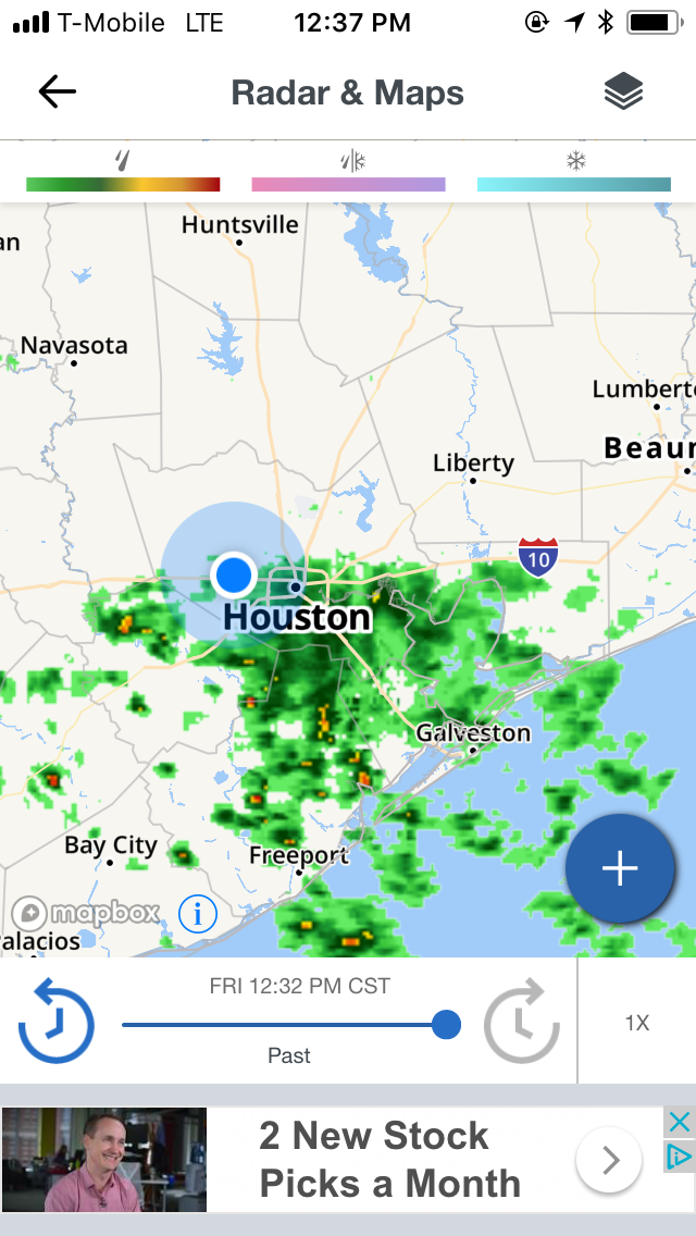
Houston, TX radar, during the early afternoon.

Northwest Houston, TX, during the early evening.

Houston, TX radar, during the late evening, or maybe early night.

Houston, TX radar, during the early night.
Summary: The day was cool, wet, and cloudy. Light to moderate with some moderately heavy rain showers started to pop up in and around the Houston, TX area, sometime during the morning. Light to moderate with some moderately heavy and heavy showers looked to be scattered across the Houston, TX area, during the afternoon, evening, and night. I think I started to see on and off light to moderate rain, where I work in northwest Houston, TX, sometime during the late morning. On and off light to moderate with sometimes moderately heavy and heavy showers passed over where I was in northwest Houston, TX, during the afternoon and evening. I don't think I saw any more showers after that. Maybe just a few on and off light sprinkles. Stratus clouds looked to cover the whole sky, during the morning, afternoon, evening, and night. The wind speeds looked to be calm with maybe some gentle to moderate gusts and moderately strong gusts. It felt very cool, during the early morning and late night. It felt cool, during the mid and late morning, afternoon, evening, and early night. There was a Hazardous Weather Outlook issued for the Houston, TX area for the Houston, TX area, by NOAA. There were no other watches, warnings, alerts, advisories, or weather statements/outlooks issued for the Houston, TX area, that I know of. The low temperatures looked to be in the low 40's and the high temperatures looked to be in the low to mid 50's, for the Houston, TX area.
Houston, TX Storm Summary: Light to moderate with some moderately heavy rain showers started to pop up in and around the Houston, TX area, sometime during the morning. Light to moderate with some moderately heavy and heavy showers looked to be scattered across the Houston, TX area, during the afternoon, evening, and night. I didn't see, or hear about any flooding, or damage caused by the weather to any of the locations in the Houston, TX area, during anytime of the day.
My Storm Summary: I think I started to see on and off light to moderate rain, where I work in northwest Houston, TX, sometime during the late morning. On and off light to moderate with sometimes moderately heavy and heavy showers passed over where I was in northwest Houston, TX, during the afternoon and evening. I don't think I saw any more showers after that. Maybe just a few on and off light sprinkles. The roads and ground still had a little bit of ice on them, where I was in northwest Houston, TX, during early and maybe mid-morning, but were quickly replaced with just a wet slick road and ground with some small to big puddles, where I was in northwest Houston, TX, during the late morning. The ground and roads stayed wet and slick, where I was in northwest Houston, TX, during the afternoon, evening, and night.
Locations: Northwest Houston, TX.
Thoughts: Lots of rain. More than I expected.
Area Forecast Discussion
Issued by NWS Houston/Galveston, TX
Issued by NWS Houston/Galveston, TX
Versions: 1 2 3 4 5 6 7 8 9 10 11 12 13 14 15 16 17 18 19 20 21 22 23 24 25 26 27 28 29 30 31 32 33 34 35 36 37 38 3940 41 42 43 44 45 46 47 48 49 50
000
FXUS64 KHGX 200538
AFDHGX

Area Forecast Discussion
National Weather Service Houston/Galveston TX
1138 PM CST Fri Jan 19 2018

.AVIATION...[06Z TAF]
The majority of TAF sites have dropped to LIFR/IFR conditions
with a only a few MVFR. Ceilings have dropped to below 500ft in a
lot of areas including Houston metro terminals. Visibility remains
in the 1-4 mile range with no dense fog. Still a chance some
dense fog will develop but that will hinge on winds which range
from near 10 knots for KCLL to 5 knots or less elsewhere.
Primarily IFR conditions will continue into the morning and
gradually improve to MVFR through the day. Look for IFR ceilings
to develop Saturday evening into Sunday morning with visibility
slowly lowering as well. Showers will be possible through the TAF
period with little chance of thunder.

Overpeck

&&

.PREV DISCUSSION... /ISSUED 858 PM CST Fri Jan 19 2018/

UPDATE...
Eight o`clock temperature observations are in the middle 50s
along the coast and across the northern tier of counties this
evening. The Houston metro observations were a touch cooler
ranging from 50-52 degrees, as they were seeing the occasional
break in cloud cover over the last few hours. Easterly winds will
continue to veer overnight, and onshore flow will prevail by
sunrise. The warm air advection pattern that is in place will
continue to allow both temperatures and dewpoints to rise through
the night as the coastal trough currently draped over Matagorda
Bay stretching southward into the Gulf of Mexico, shifts
eastward. Only minor changes made to the forecast in this update.
Increased cloud cover over the region tonight as cloud decks
continue to lower in height. Based off current observations and
the progression of this coastal trough, also went ahead and
increased dewpoints slightly and bumped up low temperatures
specifically across our northern tier of counties.

Patchy fog becoming areas of fog, is still expected to develop
beginning in western counties and fill in eastward through the
evening hours. Both the SREF and HRRR short term guidance are
indicating potentially dense fog developing in the early morning
hours between 06-08Z and continuing through the morning. The
threat for sea fog also creeps back into the nearshore waters,
Galveston Bay, and Matagorda Bay Saturday as ample moisture
return and warm air is advected over these cooler shelf waters.

Hathaway

PREV DISCUSSION... /ISSUED 535 PM CST Fri Jan 19 2018/

AVIATION...[00Z TAF ISSUANCE]
Water vapor satellite imagery shows upper level trough over SE
Texas and this feature should be moving east tonight into
tomorrow. Warm air advection pattern will continue regardless as a
ridge builds over Texas in response to a deepening trough over
the Desert SW. This means a rather moist airmass will remain in
place supporting low ceilings/visibility. Tonight IFR and even
LIFR conditions are expected areawide with passing showers. This
continues tomorrow with possibly some improvement in ceilings to
MVFR by afternoon. Ceilings drop again Saturday evening back to
IFR. Visibility may be restricted to a mile or less in a few areas
in the morning. Showers may also cause a brief drop in
visibility. These conditions should continue into Sunday and not
improve until a front pushes through late Sunday night.

Overpeck

PREV DISCUSSION... /ISSUED 354 PM CST Fri Jan 19 2018/

DISCUSSION...
Warmer conditions with periods of rain and fog are expected
through this weekend before a cold front arrives late Sunday.
Afternoon surface analysis shows a coastal trough stretching from
near Rockport to Victoria and south into the Gulf. East of this
feature, scattered to numerous showers aided by lift from an upper
low sliding across the region continue to build north and east
this afternoon. Expect this activity to translate east through the
evening and overnight hours as this upper low lifts towards the
lower Mississippi Valley with the coastal trough also lifting
inland and losing definition as this happens. Southerly flow will
spread across the region tonight in response, allowing low clouds
to fill in and patchy sea fog to develop along the coast. Inland
fog development will also be possible this evening and tonight,
especially as the coastal trough loses definition and weakens the
surface pressure gradient/low level winds. High resolution
guidance does indicate the potential for dense fog and will have
to monitor short term trends for any development overnight.

Periods of light showers will continue tonight through Sunday as
the region remains under an increasing warm air advection regime.
With shelf waters having cooled into the mid 40s to lower 50s, sea
fog will also be possible during this time across the marine areas
and along the coast as moisture deepens across the region. High
temperatures will warm into the lower 70s by Saturday and the mid
70s by Sunday as low level southerly flow strengthens as a lee
surface low ejects across the Central Plains. An associated
Pacific front or dryline developing across North Central/Central
Texas during the day Sunday may serve as a focus for thunderstorm
development Sunday afternoon and evening, but increasing southwest
flow aloft during this time may result in too much mid-level
stability for widespread thunderstorm development. A strong
thunderstorm cannot be ruled out along this boundary in the Brazos
Valley before a cold front overtakes it Sunday night, but the
aforementioned mid-level stability and the left front quadrant of
a 120+ knot upper level jet located over North Texas indicate this
potential may be farther north of the region.

Numerous to widespread showers and a thunderstorm or two will
develop along the cold front as it pushes southeast across the
region Sunday night, before clearing the coast Monday morning.
Surface high pressure and dry conditions build into the region
Monday through Wednesday with rain chances returning to the
coastal and marine areas by Thursday as deeper moisture pushes
back into the region.

Huffman

MARINE...
Coastal troughing moving east and active area of shows and a few
thunderstorms will continue this evening as the trough shifts east
with the upper level s/w. Winds over the coastal water will increase
slightly the remainder of the afternoon with building seas. Will
continue the SCA for the 20-60nm waters and SCEC nearshore. Fog
threat increasing slightly tonight but better chances looks to be
with lighter winds and higher dewpoints over the cold shelf waters
Saturday afternoon/night. Persistent southerly flow with a 2-4 ft
swell Saturday and Sunday. Cold front sweeps through Sunday night
and winds gradually ramp up and will likely need SCA by Sunday
midnight onwards through Monday afternoon. Showers and possibly
thunderstorms with the FROPA. This should end any lingering fog
threat.
45

AVIATION...
Band of lower CIGS from near ARM-HOU-EFD IFR/MVFR at 21z and this is
likely a good confirmation that ceilings will be dropping quickly
this  evening as coastal trough slides eastward. Patchy fog
confidence is fairly high with lower VISBY probably in the CLL-CXO-
UTS region.
45

&&

.PRELIMINARY POINT TEMPS/POPS...
College Station (CLL)      54  69  60  74  47 /  30  20  20  60  70
Houston (IAH)              51  71  60  75  54 /  30  30  20  40  70
Galveston (GLS)            55  66  59  69  56 /  50  30  20  20  60

&&

.HGX WATCHES/WARNINGS/ADVISORIES...
TX...NONE.
GM...SMALL CRAFT SHOULD EXERCISE CAUTION until 6 AM CST Saturday for
     the following zones: Coastal waters from Freeport to the
     Matagorda Ship Channel out 20 NM...Coastal waters from High
     Island to Freeport out 20 NM.

     Small Craft Advisory until 6 AM CST Saturday for the following
     zones: Waters from Freeport to the Matagorda Ship Channel
     from 20 to 60 NM...Waters from High Island to Freeport from
     20 to 60 NM.

&&

$$

Discussion...99
Aviation/Marine...39
Hazardous Weather Outlook
Hazardous Weather Outlook
National Weather Service Houston/Galveston TX
423 AM CST Fri Jan 19 2018

GMZ330-335-350-355-370-375-TXZ213-214-235>238-201030-
Brazoria-Chambers-
Coastal waters from Freeport to the Matagorda Ship Channel out
20 NM-Coastal waters from High Island to Freeport out 20 NM-
Galveston-Galveston Bay-Harris-Jackson-Matagorda-Matagorda Bay-
Waters from Freeport to the Matagorda Ship Channel from 20 to
60 NM-Waters from High Island to Freeport from 20 to 60 NM-
423 AM CST Fri Jan 19 2018

This hazardous weather outlook is for portions of Southeast Texas..

.DAY ONE...Today and Tonight

A Small Craft Advisory is in effect offshore with increasing
winds and seas expected. Periods of showers and isolated
thunderstorms are expected near the coast and offshore today and
tonight in association with an upper level disturbance and coastal
trough. Patchy sea fog, dense at times, may develop later today
and tonight in between breaks of precipitation.

.DAYS TWO THROUGH SEVEN...Saturday through Thursday

Periods of dense sea fog will likely persist until the next
frontal passage late Sunday night or early Monday morning.

.SPOTTER INFORMATION STATEMENT...

Spotter activation is not anticipated at this time.

$$
No comments:
Post a Comment